Huerta de Rey
| Huerta de Rey municipality | ||
|---|---|---|
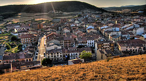
 Huerta de Rey - the townscape
|
||
| coat of arms | Map of Spain | |

|
|
|
| Basic data | ||
| Autonomous Community : | Castile and Leon | |
| Province : | Burgos | |
| Comarca : | Sierra de la Demanda (Comarca) | |
| Coordinates | 41 ° 50 ′ N , 3 ° 21 ′ W | |
| Height : | 1007 msnm | |
| Area : | 97.81 km² | |
| Residents : | 923 (Jan. 1, 2019) | |
| Population density : | 9.44 inhabitants / km² | |
| Postal code : | 09430, 09454 | |
| Municipality number ( INE ): | 09174 | |
| administration | ||
| Website : | Huerta de Rey | |
Huerta de Rey is a place and a municipality ( municipio ) belonging to the poorly populated Serranía Celtibérica with 923 inhabitants (as of January 1, 2019) in the Spanish province of Burgos in the autonomous region of Castile-León . The place was declared a National Heritage ( Bien de Interés Cultural ) in the category Conjunto histórico-artístico . All places in the municipality belong to the stations of the Camino del Cid . and to the Ruta de la Lana coming from the southeast ( Alicante / Valencia ) .
Location and climate
The place Huerta de Rey is located on the west bank of the Río Arandilla, which rises about 1 km to the north, at an altitude of about 1000 m . The next larger town, Peñaranda de Duero , is about 23 km (driving distance) in a south-westerly direction; the small but worth seeing place Coruña del Conde is about 11 km southwest. The excavation site of the Roman city of Clunia is only about 6 km southwest. The provincial capital Burgos is about 80 km to the northwest. Despite the altitude, the climate is temperate to warm; Rain (approx. 525 mm / year) falls over the year.
Population development
| year | 1857 | 1900 | 1950 | 2000 | 2018 |
| Residents | 967 | 1,201 | 1,644 | 1,173 | 932 |
The mechanization of agriculture , the abandonment of small farms and the resulting lower demand for labor have - despite the incorporation of the hamlets (pedanías) Hinojar del Rey , Peñalba de Castro and Quintanarraya - in a significant decline since the middle of the 20th century Population led.
economy
The place was and is largely agricultural, with cattle breeding and dairy farming dominating; wheat and barley are grown in some fields in the area. Tourism has been an important source of income for the municipality since the middle of the 20th century; which is considered a summer retreat. In 2012, almost the whole town won the main prize ( El Gordo ) in the Spanish Christmas lottery.
history
There is no more detailed information about the early history of the place. The Romans founded the city of Clunia just 6 km southwest , which is said to have had more than 30,000 inhabitants in its heyday in the 3rd century. A Visigoth necropolis was discovered in what is now the suburb of Hinojar del Rey . During the time of the Islamic advance, the area became depopulated; the first new settlers should be protected by a castle, but two advances by Abd ar-Rahman III. in the years 920 and 934 as well as the repeated attacks by Almansor towards the end of the 10th century, the further existence of the place was questioned again. But calm returned in the 11th century and the place was gradually repopulated ( repoblación ) . In the 12th century, Huerta de Rey came under the jurisdiction of the Santo Domingo de Silos monastery - a situation that lasted amid constant quarrels until the city charter was granted in 1637. After that, the place sank into a documentary oblivion. In 1918, a conflagration destroyed over 300 of the old half-timbered houses , but most of them were rebuilt in stone.
Attractions
- Huerta del Rey
- The three-aisled church, with simple late Gothic or Renaissance shapes, is dedicated to the legendary child martyr Pelagius of Córdoba (San Pelayo) , who was especially venerated during the Reconquista , and dates from 1587.
- The source of the Río Arandilla , about 1 km to the north, is protected by a house.
- Hinojar del Rey
- The single nave church of San Andrés dates from the 15th century; in the 16th century it received chapels on the north side and a south porch (portico) resting on simple wooden supports . Inside there are several baroque altarpieces (retablos) from the 17th and 18th centuries.
- Quintanarraya
- The three-aisled Iglesia de San Pedro de Antioquía has a portal with a multi-pass arch ; the interior contains a Romanesque font (pila bautismal) as well as several late baroque altarpieces (retablos) .
- The Ermita de Santa María and the Ermita de San Roque also belong to the townscape.
Web links
- Huerta del Rey - photos + short information (wikiburgos, spanish)
- Huerta del Rey, sights - photos + short information (Spanish)
- Hinojar del Rey - photos + short information (wikiburgos, spanish)
Individual evidence
- ↑ Cifras oficiales de población resultantes de la revisión del Padrón municipal a 1 de enero . Population statistics from the Instituto Nacional de Estadística (population update).
- ↑ Huerta del Rey - Camino del Cid
- ↑ Hinojar del Rey - Camino del Cid
- ↑ Huerta del Rey - climate tables
- ^ Huerta del Rey - population development
- ↑ Huerta del Rey - History
- ↑ Hinojar del Rey - History

