Úrbel del Castillo
| Municipality of Úrbel del Castillo | ||
|---|---|---|
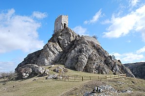
 Úrbel del Castillo - castle ruins
|
||
| coat of arms | Map of Spain | |
 Help on coat of arms |
|
|
| Basic data | ||
| Autonomous Community : |
|
|
| Province : | Burgos | |
| Comarca : | Páramos | |
| Coordinates | 42 ° 37 ′ N , 3 ° 51 ′ W | |
| Height : | 935 msnm | |
| Area : | 30.83 km² | |
| Residents : | 74 (Jan. 1, 2019) | |
| Population density : | 2.4 inhabitants / km² | |
| Postal code : | 09125 | |
| Municipality number ( INE ): | 09398 | |
| administration | ||
| Website : | Úrbel del Castillo | |
Úrbel del Castillo is a place and a municipality ( municipio ) with only 74 inhabitants (as of January 1, 2019) in the province of Burgos and the autonomous community of Castile-León in northern Spain .
Location and climate
The place Úrbel del Castillo is located about 1 km south of the Río Úrbel on the south side of the Cantabrian Mountains at an altitude of about 935 m about 39 km (driving distance) northwest of the city of Burgos . The climate in winter is harsh, but in summer it is dry and warm; Rain (approx. 695 mm / year) falls mainly in the winter half-year.
Population development
| year | 1857 | 1900 | 1950 | 2000 | 2018 |
| Residents | k. A. | 517 | 490 | 93 | 79 |
The mechanization of agriculture and the abandonment of small farms led to a significant decline in population in the second half of the 20th century. The hamlets (pedanías) La Nuez de Arriba and Quintana del Pino also belong to the municipality .
economy
Agriculture, which also included a little cattle breeding (e.g. pigs, chickens), has always played the most important role for the population of the region; Crafts, trade and service industries developed on a small scale in the village itself. Several houses in the village are now rented out as holiday apartments (casas rurales) .
history
Finds from the Celtic , Roman , Visigothic and even from the Islamic - Moorish period have not yet been made in the municipality. It is believed that the establishment of the place as well as that of the other villages in the area goes back to the instigation of the second Count of Castile , Diego Rodríguez Porcelos (r. 873-885), who - after the driving back of the Moors - strongly around tried to repopulate ( repoblación ) the area. From 1035 to 1054 the place belonged to the sphere of influence of the Kingdom of Navarre . For the first time, however, the place name Uluer or Ulver only appears in a document from 1121.
Attractions
- The castle with its dominant keep (torre del homenaje) , located on a prominent rock peak approx. 80 m above the town, was built in the 11th and 15th centuries on the site of an older watchtower, partly from rubble and partly from stone . At times she belonged to the Order of Santiago .
- The overall very defensive-looking Iglesia de Santiago Apóstol is dedicated to the Apostle James the Elder . It dates from the 16th century; the mighty bell tower (campanario) , in which the current portal is located, was added in 1633.
Web links
- Úrbel del Castillo - Photos + Info (wikiburgos, Spanish)
- Úrbel del Castillo - video
Individual evidence
- ↑ Cifras oficiales de población resultantes de la revisión del Padrón municipal a 1 de enero . Population statistics from the Instituto Nacional de Estadística (population update).
- ↑ Úrbel del Castillo - Climate tables
- ↑ Úrbel del Castillo - population development
- ↑ Úrbel del Castillo - History
- ↑ Úrbel del Castillo - Castle
- ↑ Úrbel del Castillo - Castle
- ↑ Úrbel del Castillo - Iglesia
