Huérmeces
| Huérmeces municipality | ||
|---|---|---|
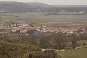
 Huérmeces - town view
|
||
| coat of arms | Map of Spain | |

|
|
|
| Basic data | ||
| Autonomous Community : |
|
|
| Province : | Burgos | |
| Comarca : | Alfoz de Burgos | |
| Coordinates | 42 ° 31 ′ N , 3 ° 46 ′ W | |
| Height : | 880 msnm | |
| Area : | 48.7 km² | |
| Residents : | 185 (Jan 1, 2019) | |
| Population density : | 3.8 inhabitants / km² | |
| Postal code : | 09150 | |
| Municipality number ( INE ): | 09172 | |
| administration | ||
| Website : | Huérmeces | |
Huérmeces is a northern Spanish town and municipality ( municipio ) with only 185 inhabitants (as of January 1, 2019) in the north of the province of Burgos in the autonomous community of Castile-León .
Location and climate
The place Huérmeces is located in the Iberian Meseta on the Río Úrbel , a tributary of the Río Arlanzón , about 27 km (driving distance) northwest of Burgos at an altitude of about 880 m . The climate in winter is often harsh, but in summer it is more temperate and warm; Rain (approx. 645 mm / year) falls mainly in the winter half-year.
Population development
| year | 1857 | 1900 | 1950 | 2000 | 2018 |
| Residents | 413 | 398 | 338 | 157 | 136 |
The mechanization of agriculture and the abandonment of small farms led to a lack of jobs and a significant decline in the number of inhabitants ( rural exodus ) since the 1950s .
economy
For centuries, Huérmeces was a self-sufficient farming village in which both fields and cattle ranching were practiced. There were several flour mills on the Río Úrbel . A wind farm (Parque Eólico Páramo de Vega) was put into operation in 2008 on the border with the neighboring municipality of Valle de Santibáñez .
history
Small prehistoric and Celtiberian finds were discovered in the area. Corresponding evidence is missing from Roman , Visigothic and Islamic times. In the 8th and early 9th centuries, the area was under Islamic influence, but the area was neither permanently settled nor defended by the Berbers due to the unusually harsh and rainy climate . At the end of the 9th century, the Castilian Count Diego Rodríguez Porcelos received from King Alfons III. of Asturias the order to repopulate ( repoblación ) the depopulated land. After or at about the same time as the founding of Burgos (884), Huérmeces was also likely to have emerged. In 1124 the place name Gormeces is first mentioned in a document.
Attractions
- The exterior of the Palacio de los Fernández-Zorrilla , with the exception of the portal, was rather simple and was built around 1700. Today it serves as an event location.
- The three-aisled Iglesia de San Juan Bautista , built in the 18th century, is dedicated to John the Baptist . Inside, the domed crossing is illuminated by a lantern . The multi-figure main altar with John the Baptist in the center is impressive; on the left the scene of the baptism of Christ , on the right the beheading of John the Baptist . The Romanesque baptismal font (pila bautismal) comes from the medieval predecessor church.
- A fountain (fuente) with an attached washing area (lavadero) or cattle trough (Abrevadero) stands on the outskirts.
- The ruins of the Torre de los Duques de Abrantes are also on the outskirts. Up to the beginning of the 20th century, the structure with its almost 2 m thick quarry stone walls was still relatively well preserved.
Web links
- Huérmeces - Photos + Info (wikiburgos, Spanish)
Individual evidence
- ↑ Cifras oficiales de población resultantes de la revisión del Padrón municipal a 1 de enero . Population statistics from the Instituto Nacional de Estadística (population update).
- ↑ Huérmeces - Climate tables
- ↑ Huérmeces - population development
- ↑ Huérmeces - wind farm
- ↑ Huermeces - History
- ↑ Huérmeces - Palacio
- ↑ Huérmeces - Church etc.
- ↑ Huérmeces - Tower ruins


