Miraveche
| Miraveche municipality | ||
|---|---|---|
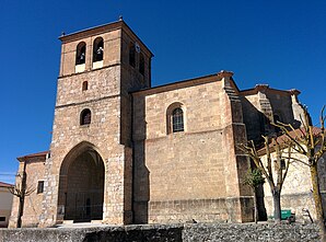
 Miraveche - Iglesia de Santa Eulalia
|
||
| coat of arms | Map of Spain | |

|
|
|
| Basic data | ||
| Autonomous Community : |
|
|
| Province : | Burgos | |
| Comarca : | La Bureba | |
| Coordinates | 42 ° 40 ′ N , 3 ° 12 ′ W | |
| Height : | 800 msnm | |
| Area : | 22.7 km² | |
| Residents : | 71 (Jan. 1, 2019) | |
| Population density : | 3.13 inhabitants / km² | |
| Postal code : | 09289 | |
| Municipality number ( INE ): | 09220 | |
| administration | ||
| Website : | Miraveche | |
Miraveche is a northern Spanish place and a municipality ( municipio ) with only 71 inhabitants (as of January 1, 2019) in the northeast of the province of Burgos in the autonomous community of Castile-León .
Location and climate
The place Miraveche is located in the south of the Montes Obarenes-San Zadornil Natural Park at an altitude of about 800 m . The city of Burgos is about 65 km (driving distance) in a south-westerly direction; the nearest town is Miranda de Ebro (approx. 31 km east). The climate in winter is harsh, but in summer it is temperate and warm; the rain, which is abundant by Spanish standards (approx. 750 mm / year), falls mainly in the winter months.
Population development
| year | 1857 | 1900 | 1950 | 2000 | 2017 |
| Residents | 291 | 639 | 494 | 119 | 75 |
The mechanization of agriculture and the abandonment of small farms led to a lack of jobs and a significant decline in the number of inhabitants (rural exodus) since the 1950s.
economy
In earlier times Miraveche was a self-sufficient farming village in the fertile and therefore agricultural surroundings of the Bureba . The field work is done by only a few farmers today; some houses are rented out as holiday apartments (casas rurales) in summer .
history
A nearby necropolis dates from Celtic times ; No evidence has yet been found from the Roman , Visigothic and Islamic times. In the 8th and early 9th centuries, the area was under Islamic influence, but the area was neither permanently settled nor defended by the Berbers due to the unusually harsh and rainy climate . At the end of the 9th century, the Castilian Count Diego Rodríguez Porcelos received from King Alfons III. of Asturias the order to repopulate ( repoblación ) the depopulated land. The first mention of the place name Miaraueg comes from the year 1122.
Attractions
- The Iglesia de Santa Eulalia is dedicated to the early Christian martyr Eulalia of Mérida . It is an outwardly nondescript late-Gothic hall church from the 16th century, the three ships of imposing stellar vaults are spanned.
- Surroundings
- An Iron Age Celtic necropolis is located on a hill about 1 km outside the village. Several 50 cm high stones mark the graves so that they were not accidentally occupied twice. Iron swords were found in some of them as grave goods (see municipal coat of arms ).
Web links
- Miraveche - Photos + Info (wikiburgos, Spanish)
Individual evidence
- ↑ Cifras oficiales de población resultantes de la revisión del Padrón municipal a 1 de enero . Population statistics from the Instituto Nacional de Estadística (population update).
- ↑ Miraveche climate: average temperature, weather by month, Miraveche weather averages. Retrieved June 5, 2019 .
- ↑ Habitantes Miraveche 1900-2018. Retrieved June 5, 2019 (Spanish).
- ↑ Historia | Miraveche. Retrieved June 5, 2019 (Spanish).
- ↑ © todos los derechos reservados Abilio Estefanía: Necrópolis de Miraveche. Retrieved June 5, 2019 (Spanish).
