La Bureba
| La Bureba | |
|---|---|

|
|
| Comarca La Bureba (light green) in the province of Burgos | |
| Basic data | |
| Main place: | Briviesca |
| Surface: | 1064 km² |
| Residents: | about 10,000 |
| Post Code: | 09240-09271 |
| Municipalities: | 44 |

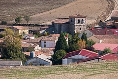
La Bureba is a landscape and an administrative unit (comarca) in the east of the northern Spanish province of Burgos in Old Castile . The main town is the small town of Briviesca .
geography
The almost 1065 km² large and approx. 600 to 800 m high area of the Bureba is comparatively rainy by Spanish standards (approx. 700 mm / year) and accordingly fertile. It is located south of the Montes Obarenes , whose highest peak is the Pico Humión (1435 m). The most important rivers are the Río Homino , the Río Oroncillo , the Río Oca and the Río Tirón , whose water ultimately flows into the Ebro and thus into the Mediterranean .
Population and economy
While the total population of the region was around 40,000 at the beginning of the 20th century, it is only around 10,000 today. The most important branch of business was and is agriculture, with agriculture ( wheat , sunflowers etc.) dominating; Livestock farming plays only a very minor role, as does viticulture, but the txakoli (or chacoli ) typical of the region should be tried.
Municipalities (municipios)
history
The so-called "Corridor of La Bureba" has always functioned as an important link between the upper Ebro valley and the middle Duero valley. The so-called Homo antecessor, who lived about 1 million years ago, roamed the area; Evidence from the Old and New Stone Age is also known. Before the arrival of the Romans , the area was populated by the Celtic people of the Autrigones . Visigoths and even the Moors , which dominated northern Spain in large parts in the 8th and 9th centuries , hardly left any traces. Already in the years between 850 and 930 the Moors, mostly of Berber origin, were pushed aside by the up-and-coming Counts of Castile to the Duero border. At the end of the 9th century, the Castilian Count Diego Rodríguez Porcelos received from King Alfons III. of Asturias the order to repopulate ( repoblación ) the depopulated area with Christians from the north or south of the Iberian Peninsula . Names like Boruevan (867) or Borovia (975), which - probably of Celtic origin - denote today's region for the first time, date from this time . Today the area of the Bureba borders the La Rioja region in the east ; in the high Middle Ages (until 1176/77) it was disputed between the kingdoms of Castile and Navarre . From the northeast ( Bayonne , Irun ) a branch line of led St. James on Briviesca to Burgos where this on to Santiago de Compostela leading main road ( Camino Francés ) met.
Attractions
In the Bureba there are only a few legacies from the time of the megalithic cultures as well as the Celts and Romans. In contrast, there are numerous Romanesque churches and chapels (ermitas) ; many more were demolished in the late Middle Ages or early modern times and replaced by larger Gothic or Baroque buildings.
See also
Web links
- La Bureba, history and sights - photos + information (Spanish)
- La Bureba, history etc. - photos, map + information (Spanish)
- La Bureba, circuit - photos + information (Spanish)

