
Poza de la Sal
| Poza de la Sal municipality | |||
|---|---|---|---|
 Poza de la Sal - View of the town with the castle
|
|||
| coat of arms | Map of Spain | ||
 Help on coat of arms |
|
||
| Basic data | |||
| Autonomous Community : |
|
||
| Province : | Burgos | ||
| Comarca : | La Bureba | ||
| Coordinates | 42 ° 40 ′ N , 3 ° 30 ′ W | ||
| Height : | 765 msnm | ||
| Area : | 81.9 km² | ||
| Residents : | 287 (Jan. 1, 2019) | ||
| Population density : | 3.5 inhabitants / km² | ||
| Postal code : | 09246 | ||
| Municipality number ( INE ): | 09272 | ||
| administration | |||
| Website : | Poza de la Sal | ||

Poza de la Sal is a place and a municipality ( municipio ) with 287 inhabitants (as of January 1, 2019) in the north of the Spanish province of Burgos in the autonomous region of Castile-León . The entire town center is recognized as a cultural asset ( Bien de Interés Cultural ) in the Conjunto histórico-artístico category .
Location and climate
The place Poza de la Sal is located in the fertile region of the Bureba at an altitude of approx. 765 m . The provincial capital Burgos is located approx. 47 km (driving distance) southwest; the lovely town of Briviesca is a good 23 km southeast. The climate is temperate to warm; The rain, which is abundant by Spanish standards (approx. 735 mm / year) falls - with the exception of the summer months - over the year.
Population development
| year | 1857 | 1900 | 1950 | 2000 | 2017 |
| Residents | 2,447 | 1.952 | 1,318 | 384 | 303 |
As a result of the mechanization of agriculture , the abandonment of small farms and the resulting lack of jobs, the population of the community experienced a collapse in the middle of the 20th century. The municipality also includes the two hamlets (pedanías) Castil de Lences and Lences (de Bureba), each with around 40 inhabitants .
economy
From the Middle Ages to the first half of the 20th century, the place was the artisanal and mercantile center of several villages and individual farms in the area; the salt pans formed an important source of income . Today the cultivation of grain and livestock are important; Tourism in the form of renting holiday apartments is also an important source of income for the municipality.
history
The place was originally a settlement of the Celtic Autrigones and was then called Salionca ; the Romans also mined salt here. Visigothic and even Moorish traces are missing. At the end of the 9th and beginning of the 10th century, the Moors were pushed back into the areas south of the Duero ( reconquista ) under the leadership of the Castilian Counts Diego Rodríguez Porcelos (r. 873–885) and Fernán González ; thereafter a policy of repopulation ( repoblación ) was carried out in the areas north of the Duero . At the end of the 10th century, the Muslim military leader Almansor devastated the region for the last time. In the Middle Ages, the then small town received a castle (castillo) on a rock and was surrounded by a wall.
Attractions
.jpg)
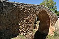
- The ruins of the Castillo de los Rojas are perched on a rock high above the town. Parts of the medieval city wall (muralla) are still preserved.
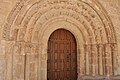
- The three-aisled church of San Cosme y San Damián is a work of the 13th century; however, it received a new portal in the 17th century. The late baroque altarpiece (retablo) shows the two patron saints and other figures.
- Numerous half-timbered houses adorn the town center.
- The salt dome is one of the largest in Europe; the water is channeled through small aqueducts through the town to the saline basins located approx. 1 km to the northwest.
- Lences de Bureba
- The church in the village about 6 km to the south has a Romanesque origin, but it was later Gothicized. A south porch ( portico ) that protects the impressive Romanesque archivolt portal is rare that far north .
- Nearby, a single arched late medieval bridge with a raised apex crosses one of the region's many streams.
- Castil de Lences
- The Monasterio de la Asunción has medieval origins; the apse of the church and the cloister (claustro) date from the end of the 14th century, but most of the monastery buildings were modernized at a later date and the chapter house is spanned by an artesonado wooden ceiling.
- The simple church of the place is Romanesque.

Lences - church
Lences - church portal
Lences - bridge

Castil de Lences - church
.jpg)
.jpg)
.jpg)
.jpg)
Web links
- Poza de la Sal and surroundings, sights - photos + information (arteguias, Spanish)
Individual evidence
- ↑ Cifras oficiales de población resultantes de la revisión del Padrón municipal a 1 de enero . Population statistics from the Instituto Nacional de Estadística (population update).
- ↑ Poza de la Sal - climate tables
- ↑ Poza de la Sal - population development
- ↑ Poza de la Sal - castle and city wall
- ↑ Poza de la Sal - castle and city wall
- ↑ Poza de la Sal - Church
Abajas | Adrada de Haza | Aguas Cándidas | Aguilar de Bureba | Albillos | Alcocero de Mola | Alfoz de Bricia | Alfoz de Quintanadueñas | Alfoz de Santa Gadea | Altable | Los Altos | Ameyugo | Anguix | Aranda de Duero | Arandilla | Arauzo de Miel | Arauzo de Salce | Arauzo de Torre | Arcos | Arenillas de Riopisuerga | Arija | Arlanzón | Arraya de Oca | Atapuerca | Los Ausines | Avellanosa de Muñó | Bahabón de Esgueva | Los Balbases | Baños de Valdearados | Bañuelos de Bureba | Barbadillo de Herreros | Barbadillo del Mercado | Barbadillo del Pez | Barrio de Muñó | Los Barrios de Bureba | Barrios de Colina | Basconcillos del Tozo | Bascuñana | Belbimbre | Belorado | Berberana | Berlangas de Roa | Berzosa de Bureba | Bozoó | Brazacorta | Briviesca | Bugedo | Buniel | Burgos | Busto de Bureba | Cabañes de Esgueva | Cabezón de la Sierra | Caleruega | Campillo de Aranda | Campolara | Canicosa de la Sierra | Cantabrana | Carazo | Carcedo de Bureba | Carcedo de Burgos | Cardeñadijo | Cardeñajimeno | Cardeñuela Riopico | Carrias | Cascajares de Bureba | Cascajares de la Sierra | Castellanos de Castro | Castil de Peones | Castildelgado | Castrillo de la Reina | Castrillo de la Vega | Castrillo de Riopisuerga | Castrillo del Val | Castrillo Mota de Judíos | Castrojeriz | Cavy | Cayuela | Cebrecos | Celada del Camino | Cerezo de Río Tirón | Cerratón de Juarros | Ciadoncha | Cillaperlata | Cilleruelo de Abajo | Cilleruelo de Arriba | Ciruelos de Cervera | Cogollos | Condado de Treviño | Contreras | Coruña del Conde | Covarrubias | Cubillo del Campo | Cubo de Bureba | La Cueva de Roa | Cuevas de San Clemente | Encío | Espinosa de Cervera | Espinosa de los Monteros | Espinosa del Camino | Estépar | Fontioso | Frandovínez | Fresneda de la Sierra Tirón | Fresneña | Fresnillo de las Dueñas | Fresno de Río Tirón | Fresno de Rodilla | Frías | Fuentebureba | Fuentecén | Fuentelcésped | Fuentelisendo | Fuentemolinos | Fuentenebro | Fuentespina | Galbarros | La Gallega | Grijalba | Grisaleña | Gumiel de Izán | Gumiel de Mercado | Hacinas | Haza | Hontanas | Hontangas | Hontoria de la Cantera | Hontoria de Valdearados | Hontoria del Pinar | Las Hormazas | Hornillos del Camino | La Horra | Hortigüela | Hoyales de Roa | Huérmeces | Huerta de Arriba | Huerta de Rey | Humada | Hurones | Ibeas de Juarros | Ibrillos | Iglesiarrubia | Iglesias | Isar | Itero del Castillo | Jaramillo de la Fuente | Jaramillo Quemado | Junta de Traslaloma | Junta de Villalba de Losa | Jurisdicción de Lara | Jurisdicción de San Zadornil | Lerma | Llano de Bureba | Madrigal del Monte | Madrigalejo del Monte | Mahamud | Mambrilla de Castrejón | Mambrillas de Lara | Mamolar | Manciles | Mazuela | Mecerreyes | Medina de Pomar | Melgar de Fernamental | Merindad de Cuesta-Urria | Merindad de Montija | Merindad de Río Ubierna | Merindad de Sotoscueva | Merindad de Valdeporres | Merindad de Valdivielso | Milagros | Miranda de Ebro | Miraveche | Modúbar de la Emparedada | Monasterio de la Sierra | Monasterio de Rodilla | Moncalvillo | Monterrubio de la Demanda | Montorio | Moradillo de Roa | Nava de Roa | Navas de Bureba | Nebreda | Neila | Olmedillo de Roa | Olmillos de Muñó | Oña | Oquillas | Orbaneja Riopico | Padilla de Abajo | Padilla de Arriba | Padrones de Bureba | Palacios de la Sierra | Palacios de Riopisuerga | Palazuelos de la Sierra | Palazuelos de Muñó | Pampliega | Pancorbo | Pardilla | Partido de la Sierra en Tobalina | Pedrosa de Duero | Pedrosa de Río Úrbel | Pedrosa del Páramo | Pedrosa del Príncipe | Peñaranda de Duero | Peral de Arlanza | Piérnigas | Pineda de la Sierra | Pineda Trasmonte | Pinilla de los Barruecos | Pinilla de los Moros | Pinilla Trasmonte | Poza de la Sal | Prádanos de Bureba | Pradoluengo | Presencio | La Puebla de Arganzón | Puentedura | Quemada | Quintana del Pidio | Quintanabureba | Quintanaélez | Quintanaortuño | Quintanapalla | Quintanar de la Sierra | Quintanavides | Quintanilla de la Mata | Quintanilla del Agua y Tordueles | Quintanilla del Coco | Quintanilla San García | Quintanilla Vivar | Las Quintanillas | Rabanera del Pinar | Rábanos | Rabé de las Calzadas | Rebolledo de la Torre | Redecilla del Camino | Redecilla del Campo | Regumiel de la Sierra | Reinoso | Retuerta | Revilla del Campo | Revilla Vallejera | La Revilla y Ahedo | Revillarruz | Rezmondo | Riocavado de la Sierra | Roa | Rojas | Royuela de Río Franco | Rubena | Rublacedo de Abajo | Rucandio | Salas de Bureba | Salas de los Infantes | Saldaña de Burgos | Salinillas de Bureba | San Adrián de Juarros | San Juan del Monte | San Mamés de Burgos | San Martín de Rubiales | San Millán de Lara | San Vicente del Valle | Santa Cecilia | Santa Cruz de la Salceda | Santa Cruz del Valle Urbión | Santa Gadea del Cid | Santa Inés | Santa María del Campo | Santa María del Invierno | Santa María del Mercadillo | Santa María Rivarredonda | Santa Olalla de Bureba | Santibáñez de Esgueva | Santibáñez del Val | Santo Domingo de Silos | Sargentes de la Lora | Sarracín | Sasamón | La Sequera de Haza | Solarana | Sordillos | Sotillo de la Ribera | Sotragero | Sotresgudo | Susinos del Páramo | Tamarón | Tardajos | Tejada | Terradillos de Esgueva | Tinieblas de la Sierra | Tobar | Tordómar | Torrecilla del Monte | Torregalindo | Torrelara | Torrepadre | Torresandino | Tórtoles de Esgueva | Tosantos | Trespaderne | Tubilla del Agua | Tubilla del Lago | Úrbel del Castillo | Vadocondes | Valdeande | Valdezate | Valdorros | Vallarta de Bureba | Valle de las Navas | Valle de Losa | Valle de Manzanedo | Valle de Mena | Valle de Oca | Valle de Santibáñez | Valle de Sedano | Valle de Tobalina | Valle de Valdebezana | Valle de Valdelaguna | Valle de Valdelucio | Valle de Zamanzas | Vallejera | Valles de Palenzuela | Valluércanes | Valmala | La Vid de Bureba | La Vid y Barrios | Vileña | Villadiego | Villaescusa de Roa | Villaescusa la Sombría | Villaespasa | Villafranca Montes de Oca | Villafruela | Villagalijo | Villagonzalo Pedernales | Villahoz | Villalba de Duero | Villalbilla de Burgos | Villalbilla de Gumiel | Villaldemiro | Villalmanzo | Villamayor de los Montes | Villamayor de Treviño | Villambistia | Villamedianilla | Villamiel de la Sierra | Villangómez | Villanueva de Argaño | Villanueva de Carazo | Villanueva de Gumiel | Villanueva de Teba | Villaquirán de la Puebla | Villaquirán de los Infantes | Villarcayo de Merindad de Castilla la Vieja | Villariezo | Villasandino | Villasur de Herreros | Villatuelda | Villaverde del Monte | Villaverde-Mogina | Villayerno Morquillas | Villazopeque | Villegas | Villoruebo | Viloria de Rioja | Vilviestre del Pinar | Vizcaínos | Zael | Zarzosa de Río Pisuerga | Zazuar | Zuñeda