Tordómar
| Tordómar municipality | ||
|---|---|---|
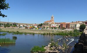
 Tordómar - View of the town with the bridge over the Arlanza river
|
||
| coat of arms | Map of Spain | |

|
|
|
| Basic data | ||
| Autonomous Community : |
|
|
| Province : | Burgos | |
| Comarca : | Arlanza (Comarca) | |
| Coordinates | 42 ° 3 ′ N , 3 ° 52 ′ W | |
| Height : | 808 msnm | |
| Area : | 30.06 km² | |
| Residents : | 336 (Jan. 1, 2019) | |
| Population density : | 11.18 inhabitants / km² | |
| Postal code : | 09341 | |
| Municipality number ( INE ): | 09384 | |
| administration | ||
| Website : | Tordómar | |
Tordómar is a northern Spanish town and a municipality ( municipio ) with a total of 336 inhabitants (at January 1, 2019) in the west of the province of Burgos in the autonomous community of Castile and Leon .
Location and climate
Tordómar is located on the north bank of the Río Arlanza at an altitude of about 808 m about 45 km (driving distance) southwest of Burgos . The medieval town of Covarrubias is approx. 32 km to the east, the Renaissance town of Lerma only 10 km. The climate in winter is harsh, but in summer it is dry and warm; Rain (approx. 500 mm / year) falls mainly in the winter half-year.
Population development
| year | 1857 | 1900 | 1950 | 2000 | 2017 |
| Residents | 552 | 690 | 770 | 402 | 351 |
The mechanization of agriculture and the abandonment of small farms led to a continuous population decline in the second half of the 20th century.
economy
The area around Tordómar is dominated by agriculture; the place offered the necessary regional services in the fields of handicraft and trade. The municipality belongs to the Arlanza (DO) wine-growing region . The tourism sector is of minor importance.
history
Tordómar was on a trade route already used in Roman times, which connected the cities of Clunia and Castrum Sigerici ( Castrojeriz ); The 22-arched bridge over the Río Arlanza, which was flanked by two milestones ( miliaria ) , probably dates from the imperial era . However, there are no text sources and finds from late antiquity, early medieval or Islamic times and thus no reliable knowledge. The first mention of the place by name comes from the 10th century, when the place was again conquered by the Christians ( reconquista ) and was resettled ( repoblación ) . In the monastery of San Pedro de Valeránica , which no longer exists today , numerous Bible copies (e.g. the famous Codex biblicus legionensis ) and other documents of the time were created.
Attractions
- The 22-arch Roman bridge is an important testimony to local history; it was repaired again and again in the Middle Ages and thereafter, so that very little of the original construction has been preserved. For a long time it served the shepherds and their flocks of sheep on the Cañada Real Burgalesa as the only way to cross the Río Arlanza.
- At the bridge are two milestones ( miliaria ) from Roman times with inscriptions from Emperor Trajan ; the larger one was Christianized with a baroque stone cross.
- The Gothic Iglesia de Santa Cruz (sometimes also Iglesia de Santa María ) is a three-aisled building from the 13th / 14th centuries. Century with later changes. It has a star vault and an apse with an adjoining bell tower (campanario) , the ground floor of which houses another apse.
Web links
Individual evidence
- ↑ Cifras oficiales de población resultantes de la revisión del Padrón municipal a 1 de enero . Population statistics from the Instituto Nacional de Estadística (population update).
- ↑ Tordómar - climate tables
- ↑ Tordómar - Population Development
- ↑ Tordómar - History
- ↑ Tordómar Church, photos


