Santo Domingo de Silos (Burgos)
| Santo Domingo de Silos parish | ||
|---|---|---|
 Santo Domingo de Silos - town center
|
||
| coat of arms | Map of Spain | |

|
|
|
| Basic data | ||
| Autonomous Community : |
|
|
| Province : | Burgos | |
| Comarca : | Sierra de la Demanda | |
| Coordinates | 41 ° 58 ′ N , 3 ° 25 ′ W | |
| Height : | 1000 msnm | |
| Area : | 78.91 km² | |
| Residents : | 279 (Jan 1, 2019) | |
| Population density : | 3.54 inhabitants / km² | |
| Postal code : | 09610 | |
| Municipality number ( INE ): | 09358 | |
| administration | ||
| Website : | Santo Domingo de Silos | |

Santo Domingo de Silos is a place and one from the main village and three hamlets (Pedanías) existing municipality ( municipio ) with a total of 279 inhabitants (at January 1, 2019) in the province of Burgos in the autonomous community of Castile and Leon . The place is on the Camino del Cid and the Ruta de la Lana , a branch of the Camino de Santiago leading from Alicante or Valencia to Burgos and is best known for its Romanesque monastery of the same name ; it is recognized as a cultural asset ( Bien de Interés Cultural ) in the Conjunto histórico-artístico category . Together with the municipalities of Lerma and Covarrubias , Santo Domingo de Silos forms the so-called "Triangle of Arlanza" (Triángulo de Arlanza) .
Location and climate
Santo Domingo de Silos is located on the Río Mataviejas in a remote mountain landscape near the Yecla Gorge at an altitude of about 1000 m . The distance to Burgos is almost 60 km (driving distance) to the north; to Madrid it is about 210 km to the south. The climate is temperate to warm; Rain (approx. 540 mm / year) falls over the year.
Population development
| year | 1857 | 1900 | 1950 | 2000 | 2017 |
| Residents | 1,154 | 1,221 | 1,020 | 316 | 282 |
The mechanization of agriculture and the abandonment of small farms led to a loss of jobs in the second half of the 20th century and triggered a rural exodus. Today the municipality belongs to the poorly populated Serranía Celtibérica .
economy
The economic basis of the town's development was the medieval Benedictine monastery, only a short distance from the Spanish Way of St. James . In the first years of its existence, the monks still worked largely on their own, true to the principle of ora et labora , but in the course of time dependent farmers and artisans increasingly carried out the necessary work for the abbey, which had become prosperous through pilgrimage gifts and foundations. Today tourism plays the dominant role in the economic life of the place.
history
Already in Visigothic times there was a small monastic community, which perished in the years of Islamic expansion, but was revived in the 10th century during the Reconquista under Fernán González . From the middle of the 11th century, the remote place became the scene of a huge new church and monastery, of which only the Romanesque cloister remains, thanks to the initiatives of a monk (later abbot) named Dominikus (Spanish: Domingo ) and the rich foundations of Ferdinand I. (claustro) is preserved; the current church and the other monastery buildings date from the 18th and 19th centuries and are built in a neoclassical style .
Attractions
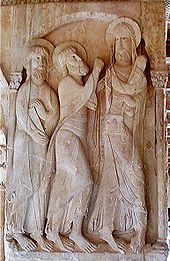
- The focus of visitor interest is the Romanesque cloister of the medieval monastery , which was built towards the end of the 11th century, with its rich and unusual sculptural decoration. An image panel at one of the four pillars shows Christ with a shell decorated pilgrim bag (ie, as Jakobspilger ) and accompanied by two followers. His legs are crossed, which indicates a certain inner tension (haste). The robes and halos of the figures partially overlap the architectural framework, which underlines the lively impression of the scene.
- The central square of the town (Plaza Mayor) has been largely restored .

- The parish church of the village is dedicated to St. Petrus (San Pedro) and contains parts from the 12th to 17th centuries.
- An old stone bridge over the Río Mataviejas, the city gate behind it and some - unfortunately badly ruined - Castilian half-timbered houses are also nice to look at.
- On the outskirts there is a covered washing area (lavadero) with an attached cattle trough (abrevadero) .
See also
Web links
Individual evidence
- ↑ Cifras oficiales de población resultantes de la revisión del Padrón municipal a 1 de enero . Population statistics from the Instituto Nacional de Estadística (population update).
- ↑ http://caminodelcid.grupotecopy.es/index.php?option=com_zoo&task=item&item_id=504&Itemid=653&lang=es Santo Domingo de Silos - Conjunto histórico-artístico
- ↑ Santo Domingo de Silos - climate tables
- ↑ Santo Domingo de Silos - Population Development


