Terradillos de Esgueva
| Terradillos de Esgueva municipality | ||
|---|---|---|
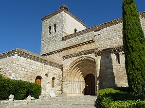
 Terradillos de Esgueva - Iglesia San Andrés
|
||
| coat of arms | Map of Spain | |

|
|
|
| Basic data | ||
| Autonomous Community : | Castile and Leon | |
| Province : | Burgos | |
| Comarca : | Ribera del Duero | |
| Coordinates | 41 ° 49 ′ N , 3 ° 51 ′ W | |
| Height : | 860 msnm | |
| Area : | 14.39 km² | |
| Residents : | 78 (Jan. 1, 2019) | |
| Population density : | 5.42 inhabitants / km² | |
| Postal code : | 09442 | |
| Municipality number ( INE ): | 09380 | |
| administration | ||
| Website : | Terradillos de Esgueva | |
Terradillos de Esgueva is a place and a municipality (municipio) with only 78 inhabitants (as of January 1, 2019) in the south of the province of Burgos in the autonomous community of Castile and León .
Location and climate
The place Terradillos de Esgueva is located on the south bank of the Río Esgueva in the Iberian Meseta almost 70 km (driving distance) south of the provincial capital Burgos at an altitude of about 860 m . The next larger city is Aranda de Duero (approx. 24 km southeast). The climate is temperate to warm; the rather sparse rain (approx. 475 mm / year) falls - with the exception of the summer months - over the year.
Population development
| year | 1857 | 1930 | 1950 | 2000 | 2017 |
| Residents | - | 285 | 270 | 129 | 79 |
Until 1927, the place and its surrounding area belonged to the neighboring municipality of Villatuelda . The mechanization of agriculture and the abandonment of small farms have led to a lack of jobs and a migration of a large part of the population to the cities since the 1950s ( rural exodus ).
economy
The region has been shaped almost exclusively by agriculture for centuries; the livestock has little meaning. Tourism (rental of holiday apartments) is also of minor importance. The municipality belongs to the Ribera del Duero wine region .
history
Finds from the Celtic , Roman , Visigothic and even from the Islamic - Moorish period have not yet been made in the municipality. The latter left the area under Christian pressure ( reconquista ) as early as the 10th century, but at the end of the century the armies of Almansor penetrated again to the north of the Iberian Peninsula . The first mention of the place name comes from the year 1054; During this time, the place and its church belonged to the San Pedro de Arlanza monastery, about 60 km northeast . A little later, the Las Huelgas monastery in Burgos took over the manorial rule , which passed to secular lords in the 15th century at the latest.
Attractions
The local parish church of San Andrés Apóstol , which can be reached via a semicircular multi-step staircase and is largely made of precisely hewn stones, dates from the late 12th century; it rises on the highest point of the place. The archivolt portal , which protrudes slightly from the surrounding wall, is structured sixfold, but otherwise unadorned; it is covered by a larger and a smaller zigzag band and forms the architectural and decorative highlight of the church. It has a single nave and almost no windows; immediately in front of the semicircular apse , two side chapels were added so that the whole almost looks like a transept . The bell tower (campanario) built on a rectangular floor plan is a work of the 18th century.
Web links
Individual evidence
- ↑ Cifras oficiales de población resultantes de la revisión del Padrón municipal a 1 de enero . Population statistics from the Instituto Nacional de Estadística (population update).
- ↑ Terradillos de Esgueva - Climate tables
- ↑ Terradillos de Esgueva - Population development
- ↑ Terradillos de Esgueva - History
- ↑ Terradillos de Esgueva - Church

