
Hontoria de la Cantera
| Municipality of Hontoria de la Cantera | |||
|---|---|---|---|
 Hontoria de la Cantera - the townscape
|
|||
| coat of arms | Map of Spain | ||

|
|
||
| Basic data | |||
| Autonomous Community : |
|
||
| Province : | Burgos | ||
| Comarca : | Alfoz de Burgos | ||
| Coordinates | 42 ° 11 ′ N , 3 ° 39 ′ W | ||
| Height : | 950 msnm | ||
| Area : | 19.39 km² | ||
| Residents : | 146 (Jan 1, 2019) | ||
| Population density : | 7.53 inhabitants / km² | ||
| Postal code : | 09351 | ||
| Municipality number ( INE ): | 09162 | ||
| administration | |||
| Website : | Hontoria de la Cantera | ||

Hontoria de la Cantera is a place and a municipality ( municipio ) belonging to the poorly populated Serranía Celtibérica with 146 inhabitants (as of January 1, 2019) in the Spanish province of Burgos in the autonomous region of Castile-León . Hontoria de la Cantera is one of the stations of the Camino del Cid and the Ruta de la Lana coming from the southeast ( Alicante / Valencia ) .
Location and climate
The place Hontoria de la Cantera is located in the headwaters of the Río de los Ausines at an altitude of about 950 m . The provincial capital Burgos is about 21 km (driving distance) to the north; the small but worth seeing place Covarrubias is about 21 km southeast. Despite the altitude, the climate is temperate to warm; Rain (approx. 555 mm / year) falls over the year.
Population development
| year | 1857 | 1900 | 1950 | 2000 | 2018 |
| Residents | 416 | 420 | 465 | 127 | 146 |
The mechanization of agriculture , the abandonment of small farms and the resulting lower demand for labor have led to a significant decline in the number of inhabitants since the middle of the 20th century.
economy
The place was and is largely agricultural, with cattle breeding and dairy farming dominating; wheat and barley are grown in some fields in the area. In the vicinity of the place there are several quarries (canteras) , in which the limestone for the construction of the cathedral of Burgos and other buildings in the region was extracted.
history
Although the Romans are said to have operated quarries here, there are no reports from the Visigothic and Islamic-Moorish times. The Castilian Count Fernán Gonzales conquered the region as early as the 10th century . The first mention of the place name Fontoria at that time is found in the founding document of the Oña monastery , which is about 80 km northeast . Shortly after the middle of the 11th century, the place fell to the monastery of San Pedro de Arlanza , but the Bishop of Burgos also stretched his fingers to increase the property of the cathedral. Since the end of the 11th century, the manor over the place was in the hands of private landlords (señores) .
Attractions

- The Iglesia de San Miguel Arcángel , built in the late 16th century and consecrated to the Archangel Michael , towers over the town. It is a Renaissance church, stabilized by buttresses , with two small but fine portals, the interior of which is designed as a three-aisled hall church with rib vaults . The late baroque altarpiece (retablo) is an eye-catcher .
- In the square in front of the church there is a calvary cross on a multi-tiered square base.
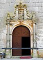
West portal

South portal

Hall church

Calvary Cross
_-_Portada_de_San_Miguel.jpg)


Web links
- Hontoria de la Cantera - photos + brief information (wikiburgos, spanish)
Individual evidence
- ↑ Cifras oficiales de población resultantes de la revisión del Padrón municipal a 1 de enero . Population statistics from the Instituto Nacional de Estadística (population update).
- ↑ Hontoria de la Cantera - Camino del Cid
- ↑ Hontoria de la Cantera - climate tables
- ^ Hontoria de la Cantera - population development
- ↑ Hontoria de la Cantera - History
Abajas | Adrada de Haza | Aguas Cándidas | Aguilar de Bureba | Albillos | Alcocero de Mola | Alfoz de Bricia | Alfoz de Quintanadueñas | Alfoz de Santa Gadea | Altable | Los Altos | Ameyugo | Anguix | Aranda de Duero | Arandilla | Arauzo de Miel | Arauzo de Salce | Arauzo de Torre | Arcos | Arenillas de Riopisuerga | Arija | Arlanzón | Arraya de Oca | Atapuerca | Los Ausines | Avellanosa de Muñó | Bahabón de Esgueva | Los Balbases | Baños de Valdearados | Bañuelos de Bureba | Barbadillo de Herreros | Barbadillo del Mercado | Barbadillo del Pez | Barrio de Muñó | Los Barrios de Bureba | Barrios de Colina | Basconcillos del Tozo | Bascuñana | Belbimbre | Belorado | Berberana | Berlangas de Roa | Berzosa de Bureba | Bozoó | Brazacorta | Briviesca | Bugedo | Buniel | Burgos | Busto de Bureba | Cabañes de Esgueva | Cabezón de la Sierra | Caleruega | Campillo de Aranda | Campolara | Canicosa de la Sierra | Cantabrana | Carazo | Carcedo de Bureba | Carcedo de Burgos | Cardeñadijo | Cardeñajimeno | Cardeñuela Riopico | Carrias | Cascajares de Bureba | Cascajares de la Sierra | Castellanos de Castro | Castil de Peones | Castildelgado | Castrillo de la Reina | Castrillo de la Vega | Castrillo de Riopisuerga | Castrillo del Val | Castrillo Mota de Judíos | Castrojeriz | Cavy | Cayuela | Cebrecos | Celada del Camino | Cerezo de Río Tirón | Cerratón de Juarros | Ciadoncha | Cillaperlata | Cilleruelo de Abajo | Cilleruelo de Arriba | Ciruelos de Cervera | Cogollos | Condado de Treviño | Contreras | Coruña del Conde | Covarrubias | Cubillo del Campo | Cubo de Bureba | La Cueva de Roa | Cuevas de San Clemente | Encío | Espinosa de Cervera | Espinosa de los Monteros | Espinosa del Camino | Estépar | Fontioso | Frandovínez | Fresneda de la Sierra Tirón | Fresneña | Fresnillo de las Dueñas | Fresno de Río Tirón | Fresno de Rodilla | Frías | Fuentebureba | Fuentecén | Fuentelcésped | Fuentelisendo | Fuentemolinos | Fuentenebro | Fuentespina | Galbarros | La Gallega | Grijalba | Grisaleña | Gumiel de Izán | Gumiel de Mercado | Hacinas | Haza | Hontanas | Hontangas | Hontoria de la Cantera | Hontoria de Valdearados | Hontoria del Pinar | Las Hormazas | Hornillos del Camino | La Horra | Hortigüela | Hoyales de Roa | Huérmeces | Huerta de Arriba | Huerta de Rey | Humada | Hurones | Ibeas de Juarros | Ibrillos | Iglesiarrubia | Iglesias | Isar | Itero del Castillo | Jaramillo de la Fuente | Jaramillo Quemado | Junta de Traslaloma | Junta de Villalba de Losa | Jurisdicción de Lara | Jurisdicción de San Zadornil | Lerma | Llano de Bureba | Madrigal del Monte | Madrigalejo del Monte | Mahamud | Mambrilla de Castrejón | Mambrillas de Lara | Mamolar | Manciles | Mazuela | Mecerreyes | Medina de Pomar | Melgar de Fernamental | Merindad de Cuesta-Urria | Merindad de Montija | Merindad de Río Ubierna | Merindad de Sotoscueva | Merindad de Valdeporres | Merindad de Valdivielso | Milagros | Miranda de Ebro | Miraveche | Modúbar de la Emparedada | Monasterio de la Sierra | Monasterio de Rodilla | Moncalvillo | Monterrubio de la Demanda | Montorio | Moradillo de Roa | Nava de Roa | Navas de Bureba | Nebreda | Neila | Olmedillo de Roa | Olmillos de Muñó | Oña | Oquillas | Orbaneja Riopico | Padilla de Abajo | Padilla de Arriba | Padrones de Bureba | Palacios de la Sierra | Palacios de Riopisuerga | Palazuelos de la Sierra | Palazuelos de Muñó | Pampliega | Pancorbo | Pardilla | Partido de la Sierra en Tobalina | Pedrosa de Duero | Pedrosa de Río Úrbel | Pedrosa del Páramo | Pedrosa del Príncipe | Peñaranda de Duero | Peral de Arlanza | Piérnigas | Pineda de la Sierra | Pineda Trasmonte | Pinilla de los Barruecos | Pinilla de los Moros | Pinilla Trasmonte | Poza de la Sal | Prádanos de Bureba | Pradoluengo | Presencio | La Puebla de Arganzón | Puentedura | Quemada | Quintana del Pidio | Quintanabureba | Quintanaélez | Quintanaortuño | Quintanapalla | Quintanar de la Sierra | Quintanavides | Quintanilla de la Mata | Quintanilla del Agua y Tordueles | Quintanilla del Coco | Quintanilla San García | Quintanilla Vivar | Las Quintanillas | Rabanera del Pinar | Rábanos | Rabé de las Calzadas | Rebolledo de la Torre | Redecilla del Camino | Redecilla del Campo | Regumiel de la Sierra | Reinoso | Retuerta | Revilla del Campo | Revilla Vallejera | La Revilla y Ahedo | Revillarruz | Rezmondo | Riocavado de la Sierra | Roa | Rojas | Royuela de Río Franco | Rubena | Rublacedo de Abajo | Rucandio | Salas de Bureba | Salas de los Infantes | Saldaña de Burgos | Salinillas de Bureba | San Adrián de Juarros | San Juan del Monte | San Mamés de Burgos | San Martín de Rubiales | San Millán de Lara | San Vicente del Valle | Santa Cecilia | Santa Cruz de la Salceda | Santa Cruz del Valle Urbión | Santa Gadea del Cid | Santa Inés | Santa María del Campo | Santa María del Invierno | Santa María del Mercadillo | Santa María Rivarredonda | Santa Olalla de Bureba | Santibáñez de Esgueva | Santibáñez del Val | Santo Domingo de Silos | Sargentes de la Lora | Sarracín | Sasamón | La Sequera de Haza | Solarana | Sordillos | Sotillo de la Ribera | Sotragero | Sotresgudo | Susinos del Páramo | Tamarón | Tardajos | Tejada | Terradillos de Esgueva | Tinieblas de la Sierra | Tobar | Tordómar | Torrecilla del Monte | Torregalindo | Torrelara | Torrepadre | Torresandino | Tórtoles de Esgueva | Tosantos | Trespaderne | Tubilla del Agua | Tubilla del Lago | Úrbel del Castillo | Vadocondes | Valdeande | Valdezate | Valdorros | Vallarta de Bureba | Valle de las Navas | Valle de Losa | Valle de Manzanedo | Valle de Mena | Valle de Oca | Valle de Santibáñez | Valle de Sedano | Valle de Tobalina | Valle de Valdebezana | Valle de Valdelaguna | Valle de Valdelucio | Valle de Zamanzas | Vallejera | Valles de Palenzuela | Valluércanes | Valmala | La Vid de Bureba | La Vid y Barrios | Vileña | Villadiego | Villaescusa de Roa | Villaescusa la Sombría | Villaespasa | Villafranca Montes de Oca | Villafruela | Villagalijo | Villagonzalo Pedernales | Villahoz | Villalba de Duero | Villalbilla de Burgos | Villalbilla de Gumiel | Villaldemiro | Villalmanzo | Villamayor de los Montes | Villamayor de Treviño | Villambistia | Villamedianilla | Villamiel de la Sierra | Villangómez | Villanueva de Argaño | Villanueva de Carazo | Villanueva de Gumiel | Villanueva de Teba | Villaquirán de la Puebla | Villaquirán de los Infantes | Villarcayo de Merindad de Castilla la Vieja | Villariezo | Villasandino | Villasur de Herreros | Villatuelda | Villaverde del Monte | Villaverde-Mogina | Villayerno Morquillas | Villazopeque | Villegas | Villoruebo | Viloria de Rioja | Vilviestre del Pinar | Vizcaínos | Zael | Zarzosa de Río Pisuerga | Zazuar | Zuñeda