Castildelgado
| Castildelgado municipality | ||
|---|---|---|
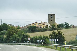
 Castildelgado - the townscape
|
||
| coat of arms | Map of Spain | |

|
|
|
| Basic data | ||
| Autonomous Community : | Castile and Leon | |
| Province : | Burgos | |
| Coordinates | 42 ° 26 ′ N , 3 ° 5 ′ W | |
| Height : | 755 msnm | |
| Area : | 4.95 km² | |
| Residents : | 36 (Jan. 1, 2019) | |
| Population density : | 7.27 inhabitants / km² | |
| Postal code : | 09259 | |
| Municipality number ( INE ): | 09082 | |
| administration | ||
| Website : | Castildelgado | |
Castildelgado is a place and a municipality ( municipio ) belonging to the poorly populated Serranía Celtibérica with only 36 inhabitants (as of January 1, 2019) in the north of the Spanish province of Burgos in the autonomous region of Castile-León . Castildelgado is located on St. James ( Camino Francés ) .
Location and climate
The town of Castildelgado is located on the Río San Julián, which is mostly dry in summer, in the east of the Castilian plateau ( meseta ) at an altitude of approx. 755 m near the border with the former Kingdom of Navarre (today La Rioja ) about halfway between the cities of Logroño (approx 58 km to the east) and Burgos (approx. 55 km to the west). The climate is temperate to warm; Rain (approx. 635 mm / year) falls over the year.
Population development
| year | 1857 | 1900 | 1950 | 2000 | 2018 |
| Residents | 226 | 146 | 158 | 82 | 36 |
The mechanization of agriculture , the abandonment of small farms and the resulting lower demand for labor have led to a significant decline in the number of inhabitants since the middle of the 20th century ( rural exodus ).
economy
The community is largely agricultural, with cattle breeding hardly playing a role.
history
Almost nothing is known about the early history of the place - Celtic , Roman , Visigoth and even Moorish traces are missing. In the Middle Ages there was a pilgrims' hospice founded by Alfonso VII († 1157) . Around the same time, the territorial conflict between Castile and Navarre began. Century was settled. In the 16th century the old place name Villaypún was given up in favor of Bishop Delgado (see below ).
Attractions
- The town's three-aisled church is dedicated to the Apostle Peter and dates from the 16th century; it is the resting place of Francisco Delgado. While the exterior, raised by a bell tower (campanario) , is almost entirely unadorned, the interior is covered by star vaults. The furnishings include several richly decorated late Baroque altarpieces (retablos) ; the main altar contains a statue of Our Lady from the 13th century.
- The Casa de los Condes de Berberana is the most important house in town.
- Only the archway and parts of the wall ring remain of a former palacio .
- The Ermita de Santa María del Campo has existed since the 13th century. The elaborately designed portal facade with its bell gable (espadaña) was added in the 18th century
Personalities
- Francisco Delgado López (1514–1576), Bishop of Lugo and Jaén , elected Bishop of Santiago de Compostela , took part in the Council of Trent (1545–1563).
literature
- Cordula Rabe: Spanish Way of St. James. From the Pyrenees to Santiago de Compostela. All stages - with variants and height profiles. Bergverlag Rother, Munich 2008, ISBN 978-3-7633-4330-0 ( Rother hiking guide ).
- Míllan Bravo Lozano: Practical pilgrim guide. The Camino de Santiago. Editorial Everest, Léon 1994, ISBN 84-241-3835-X .
Web links
- Castildelgado - Photos + Info (wikiburgos, Spanish)
- Castildelgado - Photos + Info (Spanish)
Individual evidence
- ↑ Cifras oficiales de población resultantes de la revisión del Padrón municipal a 1 de enero . Population statistics from the Instituto Nacional de Estadística (population update).
- ↑ Castildelgado - climate tables
- ↑ Castildelgado - Population Development
- ↑ Castildelgado - Church
- ↑ Castildelgado - Church
- ↑ Castildelgado - Altars
- ↑ Castildelgado - former palace
← Previous location: Redecilla del Camino 1.7 km | Castildelgado | Next town: Viloria de Rioja 1.8 km →
