Villamayor de Monjardín
| Villamayor de Monjardín municipality | ||
|---|---|---|
| coat of arms | Map of Spain | |

|
|
|
| Basic data | ||
| Autonomous Community : |
|
|
| Province : | Navarre | |
| Comarca : | Tierra Estella | |
| Coordinates | 42 ° 38 ′ N , 2 ° 6 ′ W | |
| Height : | 605 msnm | |
| Area : | 13.10 km² | |
| Residents : | 119 (Jan. 1, 2019) | |
| Population density : | 9.08 inhabitants / km² | |
| Postal code : | 31242 | |
| Municipality number ( INE ): | 31255 | |
| administration | ||
| Mayor : | Sergio Gómez Salvador | |
| Address of the municipal administration: | Plaza, 1 31242 Villamayor de Monjardín | |
Villamayor de Monjardín is a place on the Camino de Santiago in the Spanish-speaking part of the Autonomous Community of Navarre .
history
The castle on Monjardín is mentioned as Mons Garcini on the occasion of the capture by Charlemagne in 778. A count Furio, brother of the lord of the castle, is said to have been taken hostage. Chronicles of the first years of the Caliphate of Córdoba , on the other hand, say that the first Caliph had the castle razed after taking action against his opponents from Saragossa and the Ebro region.
" El conde" Mothmin "se había dado en retirada previamente, así como otras guarniciones incluida Pamplona supuestamente arrasada por el emperador franco. "
The history of the place is firmly connected with the castle above the place. It was an important bulwark against the Moorish invasion and was recaptured by King Sancho I. Garcés in 908 as part of the Reconquista . As the center and mainstay of the Moorish exercise of power in this area, this did not succeed without hard fighting. Sancho II. (Navarre) donated the castle to the Irache monastery , later it changed hands at the instigation of Sancho Mayors to the cathedral chapter of Pamplona . In the 16th century, it is among the estates of the Duke of Alba , who may have received it for the 1512 invasion of Navarre. During the Carlist Wars it was occupied alternately by Liberal and Carlist troops.
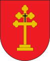
coat of arms
Description: In red a golden patriarchal cross with trefoil arms on two levels and with a black Hochkreuz occupied
Population development of the municipality

Origin of name
The traditional name of the place is only Villamayor (in the original Villa Maior ). Because the name is not mentioned until the 13th century, it is assumed that it was given when it was founded or resettled, possibly by King Sancho the Strong towards the end of the 12th century. In view of the numerous places with the same name in Spain, the Royal Geographical Society (Real Sociedad Geográfica) added the name of the nearby mountain Monjardín in February 1908, giving it the name that is still valid today. The now name-determining Monjardín also dominates the landscape around the place and was formerly called Deyo. Local tradition traces the current name back to the Navarre King Sancho I. Garcés, who is said to have found his final resting place in the castle on the top of the mountain. Monjardín would therefore come from Mons Garcini , i.e. Berg des Garcés . However, there are also authors, such as Mikel Belasko, who consider it possible that Monjardín is simply composed of monte (mountain) and jardín (garden, park) .
Because of its name, Villamayor de Monjardín is also known as the Village of the Four Lies: A joking saying goes that it is neither a city ( villa ) nor large ( mayor ), nor has nuns ( monja ) or a park ( jardín ) (Spanish: Ni es villa, ni es mayor, ni tiene monjas ni tampoco jardín ).
Attractions
- Houses decorated with coats of arms in the town center
- Church Iglesia de San Andrés Apóstol , late Romanesque church with a nave, the baroque church tower was added from the outside.
- Ermita San Esteban de Deyo or Santa Cruz de Monjardín
- Castillo de San Esteban de Deyo or Castillo de Monjardín. Fortress on the Monjardín (at 890 meters), which has been documented since the 10th century. Sancho I. Garcés captured the castle from the Moors in 908 and is said to be buried here. Today there are still some sandstone walls and the old cistern in a house with a domed vault.
- Fuente de Moros (source of the Moors). The cistern is just before Monjardín on the Camino de Santiago. It is covered with stone over a barrel vault and opens onto the path with a double arch, which is divided in the middle by a twin column with a capital . Stone steps lead down to the water.
Fiestas
Patronage festival on the second Saturday in September.
literature
- Iñaki Sagredo, Navarra, castillos que defendieron el reino , Pamplona, 2006, ISBN 84-7681-477-1 .
- Millán Bravo Lozano: Practical pilgrim guide. The Camino de Santiago . Editorial Everest, León 1994, ISBN 84-241-3835-X .
Web links
- Information about the Camino Francés
- Villamyor de Monjardín in the Bernardo Estornés Lasa - Enciclopedia Auñamendi (Basque, Spanish, English, French)
- Monjardín en la batalla de Valdejunquera. Año 920
Individual evidence
- ↑ Cifras oficiales de población resultantes de la revisión del Padrón municipal a 1 de enero . Population statistics from the Instituto Nacional de Estadística (population update).
- ↑ Location information of the Navarres regional government (Spanish)
- ↑ also possible "Maximino" ( Arabic : موثمين)


