
Moratinos (Palencia)
| Moratinos municipality | |||
|---|---|---|---|
| coat of arms | Map of Spain | ||
 Help on coat of arms |
|
||
| Basic data | |||
| Autonomous Community : |
|
||
| Province : | Palencia | ||
| Comarca : | Saldaña-Valdavia | ||
| Coordinates | 42 ° 22 ′ N , 4 ° 56 ′ W | ||
| Height : | 857 msnm | ||
| Area : | 29.40 km² | ||
| Residents : | 65 (Jan. 1, 2019) | ||
| Population density : | 2.21 inhabitants / km² | ||
| Postal code : | 34349 | ||
| Municipality number ( INE ): | 34109 | ||
| administration | |||
| Mayor : | Esteban Velasco Villarroel | ||

Moratinos is a municipality on the Camino de Santiago in the province of Palencia in the autonomous community of Castile and León .
history
The name of the place refers to its former, Moorish inhabitants, the Mudéjares .
Worth seeing
- St. Thomas Church (Iglesia de Santo Tomás)
Population development
| year | 1991 | 1996 | 2001 | 2004 | 2006 |
|---|---|---|---|---|---|
| Residents | 106 | 95 | 79 | 76 | 79 |

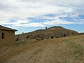
The meseta between Terratillos and Moratinos
Bodegas near Moratinos


Individual evidence
- ↑ Cifras oficiales de población resultantes de la revisión del Padrón municipal a 1 de enero . Population statistics from the Instituto Nacional de Estadística (population update).
literature
- Míllan Bravo Lozano: Practical pilgrim guide. The Camino de Santiago. Editorial Everest, Léon 1994, ISBN 84-241-3835-X .
Web links
← Previous location: Terradillos de los Templarios 3.5 km | Moratinos (Palencia) | Next town: San Nicolás del Real Camino 7 km →
Abarca de Campos | Abia de las Torres | Aguilar de Campoo | Alar del Rey | Alba de Cerrato | Amayuelas de Arriba | Ampudia | Amusco | Antigüedad | Arconada | Astudillo | Autilla del Pino | Autillo de Campos | Ayuela | Baltanás | Baquerín de Campos | Bárcena de Campos | Barruelo de Santullán | Báscones de Ojeda | Becerril de Campos | Belmonte de Campos | Berzosilla | Boada de Campos | Boadilla de Rioseco | Boadilla del Camino | Brañosera | Buenavista de Valdavia | Bustillo de la Vega | Bustillo del Páramo de Carrión | Calahorra de Boedo | Calzada de los Molinos | Capillas | Cardeñosa de Volpejera | Carrión de los Condes | Castil de Vela | Castrejón de la Peña | Castrillo de Don Juan | Castrillo de Onielo | Castrillo de Villavega | Castromocho | Cervatos de la Cueza | Cervera de Pisuerga | Cevico de la Torre | Cevico Navero | Cisneros | Cobos de Cerrato | Collazos de Boedo | Congosto de Valdavia | Cordovilla la Real | Cubillas de Cerrato | Dehesa de Montejo | Dehesa de Romanos | Dueñas | Espinosa de Cerrato | Espinosa de Villagonzalo | Cheeky | Fresno del Río | Frómista | Fuentes de Nava | Fuentes de Valdepero | Grijota | Guardo | Guaza de Campos | Hérmedes de Cerrato | Herrera de Pisuerga | Herrera de Valdecañas | Hontoria de Cerrato | Hornillos de Cerrato | Husillos | Itero de la Vega | Lagartos | Lantadilla | Ledigos | Loma de Ucieza | Lomas | Magaz de Pisuerga | Manquillos | Mantinos | Marcilla de Campos | Mazariegos | Mazuecos de Valdeginate | Melgar de Yuso | Meneses de Campos | Micieces de Ojeda | Monzón de Campos | Moratinos | Mudá | Nogal de las Huertas | Olea de Boedo | Olmos de Ojeda | Osornillo | Osorno la Mayor | Palencia | Palenzuela | Páramo de Boedo | Paredes de Nava | Payo de Ojeda | Pedraza de Campos | Pedrosa de la Vega | Perales | La Pernía | Pino del Río | Piña de Campos | Población de Arroyo | Población de Campos | Población de Cerrato | Polentinos | Pomar de Valdivia | Poza de la Vega | Pozo de Urama | Prádanos de Ojeda | La Puebla de Valdavia | Quintana del Puente | Quintanilla de Onsoña | Reinoso de Cerrato | Renedo de la Vega | Requena de Campos | Respenda de la Peña | Revenga de Campos | Revilla de Collazos | Ribas de Campos | Riberos de la Cueza | Saldaña | Salinas de Pisuerga | San Cebrián de Campos | San Cebrián de Mudá | San Cristóbal de Boedo | San Mamés de Campos | San Roman de la Cuba | Santa Cecilia del Alcor | Santa Cruz de Boedo | Santervás de la Vega | Santibáñez de Ecla | Santibáñez de la Peña | Santoyo | La Serna | Soto de Cerrato | Sotobañado y Priorato | Tabanera de Cerrato | Tabanera de Valdavia | Támara de Campos | Tariego de Cerrato | Torquemada | Torremormojón | Triollo | Valbuena de Pisuerga | Valdeolmillos | Valderrábano | Valde-Ucieza | Valle de Cerrato | Valle del Retortillo | Velilla del Río Carrión | Venta de Baños | Vertavillo | La Vid de Ojeda | Villabasta de Valdavia | Villacidaler | Villaconancio | Villada | Villaeles de Valdavia | Villahán | Villaherreros | Villalaco | Villalba de Guardo | Villalcázar de Sirga | Villalcón | Villalobón | Villaluenga de la Vega | Villamartín de Campos | Villamediana | Villameriel | Villamoronta | Villamuera de la Cueza | Villamuriel de Cerrato | Villanueva del Rebollar | Villanuño de Valdavia | Villaprovedo | Villarmentero de Campos | Villarrabé | Villarramiel | Villasarracino | Villasila de Valdavia | Villaturde | Villaumbrales | Villaviudas | Villerías de Campos | Villodre | Villodrigo | Villoldo | Villota del Páramo | Villovieco