Guenduláin
| Municipality of Cendea de Cizur: Guenduláin | ||
|---|---|---|
| coat of arms | Map of Spain | |
 Help on coat of arms |
|
|
| Basic data | ||
| Autonomous Community : |
|
|
| Province : | Navarre | |
| Comarca : | Cuenca de Pamplona | |
| Coordinates | 42 ° 46 ′ N , 1 ° 43 ′ W | |
| Height : | 780 msnm | |
| Area : | 5.56 km² | |
| Residents : | 0 (2011) INE | |
| Population density : | 0 inhabitants / km² | |
| Postal code : | 31190 | |
| Area code: | 31076000600 | |
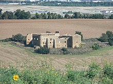
Guenduláin is a small, now abandoned place, on the Camino de Santiago near Pamplona in the autonomous community of Navarre , administratively it belongs to the municipality of Cendea de Cizur .
Here in the Pamplona Basin, according to Pseudo-Turpin , the Latin equivalent of the Roland song , the battle between Charlemagne and the Moorish general Aigolando is said to have taken place. Aigolando is said to have expected Karl here and to have died in the ensuing battle. In the fourth book, chapter eight of the Book of Jacob , however, Sahagún is given as the place of meeting.
The place is deserted today. The parish church of San Andrés from the 16th century and the castle of the Counts of Guenduláin are in a very poor structural condition.
Reports about the pilgrim hospice of a Jacobean lay brotherhood cannot be connected with any building in the place with any certainty.
Individual evidence
- ↑ Population statistics of the localities in Spain of the Instituto Nacional de Estadística ( Spanish / English)
literature
- Míllan Bravo Lozano: Practical pilgrim guide. The Camino de Santiago. Editorial Everest, Léon 1994, ISBN 84-241-3835-X .
← Previous location: Cizur Menor 4 km | Guenduláin | Next town: Zariquiegui 2 km →

