
Gonzar
| Portomarín municipality: Gonzar | |||
|---|---|---|---|
| coat of arms | Map of Spain | ||
 Help on coat of arms |
|
||
| Basic data | |||
| Autonomous Community : |
|
||
| Province : | A Coruña | ||
| Comarca : | Portomarín | ||
| Coordinates | 42 ° 50 ′ N , 7 ° 42 ′ W | ||
| Height : | 540 msnm | ||
| Residents : | 51 (January 1, 2011) INE | ||
| Area code: | 27049080000 | ||

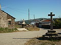
Gonzar is a place on the edge of the Camino de Santiago . It is located in the province of A Coruña of the Autonomous Community of Galicia in Spain , administratively it is dependent on Portomarín .
Worth seeing
- Parish Church of Santa Maria
Gonzar

Local passage Gonzar


Web links
Commons : Gonzar - collection of images, videos and audio files
Navigation bar St. James " Camino Francés "
← Previous location: Portomarín 6 km | Gonzar | Next town: Ligonde 8.5 km →