Espinal (Navarre)
| Municipality of Erro: Espinal / Aurizberri | ||
|---|---|---|
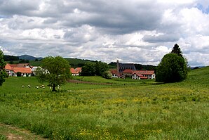
 Panorama of Espinal
|
||
| coat of arms | Map of Spain | |
 Help on coat of arms |
|
|
| Basic data | ||
| Autonomous Community : | Navarre | |
| Coordinates | 42 ° 59 ′ N , 1 ° 22 ′ W | |
| Height : | 870 msnm | |
| Residents : | 239 (2017) INE | |
| Founding: | 1269 ( Theobald II of Navarre ) | |
| Area code: | 31092000400 | |
| Official language : | Castilian , Basque | |
Espinal ( Basque Aurizberri ) is a place on the Camino de Santiago in the Basque- speaking part of the autonomous community of Navarre in Spain . Administratively, the place belongs to the municipality of Erro .
Theobald II. Of Navarre founded the market town in 1269 , "to offer to the pious pilgrims between Ronceveaux and Viscarret another space for recreation and as a guard against the frequent attacks that occur on such abandoned places". In Basque the place was named Neu- Auritz (Auritz-berri) . A bust in the village today commemorates the founder.
In the village, whose houses are often adorned with a family coat of arms carved in stone, there is a modern church, which is dedicated to the Apostle Bartholomew and which is not entirely devoid of monumental features.
The Puerto de Mezkiritz pass (922 m) lies on the Way of St. James between Espinal and Viscarret .
literature
- Míllan Bravo Lozano: Practical pilgrim guide. The Camino de Santiago. Editorial Everest, Léon 1994, ISBN 84-241-3835-X .
- Cordula Rabe: Spanish Way of St. James. From the Pyrenees to Santiago de Compostela. All stages - with variants and height profiles. Bergverlag Rother, Munich 2008, ISBN 978-3-7633-4330-0 ( Rother hiking guide ).
Web links
← Previous location: Burguete 3.5 km | Espinal (Navarre) | Next town: Bizkarreta-Gerendiain 4.7 km →
