
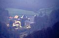
Roncesvalles
| Roncesvalles / Orreaga municipality | |||
|---|---|---|---|

|
|||
| coat of arms | Map of Spain | ||

|
|
||
| Basic data | |||
| Autonomous Community : |
|
||
| Province : | Navarre | ||
| Comarca : | Auñamendi | ||
| Coordinates | 43 ° 1 ′ N , 1 ° 19 ′ W | ||
| Height : | 962 msnm | ||
| Area : | 15.1 km² | ||
| Residents : | 22 (Jan. 1, 2019) | ||
| Population density : | 1.46 inhabitants / km² | ||
| Postal code : | 31650 | ||
| Municipality number ( INE ): | 31211 | ||
| administration | |||
| Official language : | Castilian , Basque | ||
| Mayor : | Luis Echeverría Echávarren (2003) |
||
| Website : | www.roncesvalles.es | ||
| Location of the municipality | |||

|
|||

Roncesvalles [ ˌronθesˈβaʎes ] ( Basque Orreaga , French Roncevaux , literal German translation about valley / valleys of the thorn bushes ) is a place in the autonomous region of Navarre in Spain . It is located in the Pyrenees at the southern foot of the Ibañeta Pass (Spanish: Puerto de Ibañeta , French: Col de Roncevaux ) on the Urrobi River .
The fame of the place results on the one hand from its quality as an important pilgrimage station on the Way of St. James , on the other hand from the battle of Roncesvalles on August 15, 778. The rearguard of Charlemagne's troop train was destroyed by the local Basques under the leadership of Roland . which formed the historical basis for the Roland song . There the poet himself lets the Moors appear as opposing actors under Marsilis, but this is probably due to the zeitgeist of the time.
history
Already in pre-Roman times there was a Pyrenees crossing and at the latest since the Romans and their trunk road Bordeaux-Astorga also a pass station.
Charlemagne used the passage from Roncesvalles for his Spanish campaign of 778 , while retreating the battle mentioned above came as revenge for the destruction of Pamplona by Charlemagne's troops. However, other locations are always brought into play as a place for this battle. According to legend, the rock formation of the Brèche de Roland , located almost 100 km to the east , a 40 m wide, 100 m deep and 2807 m high notch in the main ridge of the Pyrenees, above the Cirque de Gavarnie , is said to have originated from a blow by Roland with his sword Durendart .
Roncesvalles became immensely important with the establishment of the Camino de Santiago in 813: three of the four most important pilgrimage routes to Santiago de Compostela go here bundled across the Pyrenees ( Via Podiensis from Puy and Conques, Via Turonensis - from Paris, Tours and Poitiers, Via Lemovicensis - from Vézelay , Limoges and Périgueux. Via Tolosana - Arles, Toulouse - leads over the Somport ).
The coastal route with the many (feared and expensive) river crossings could thus be avoided and the Roland battlefield could be visited at the same time, even if a steep ascent and weather changes deterred the pilgrims.
The place with the old Augustinian monastery from 1132 was an important stopping point on the Way of St. James and has regained this function with the revitalization of the way.
In the valley of Roncesvalles there were battles between the Spanish and the French in April and May 1793 and on July 25, 1813 Soult ousted the English and the Spanish from their position here.
An area of land on Saturn's moon Iapetus was named Roncevaux Terra after the place or the battle .
Roncesvalles Monastery

Roncesvalles Monastery

The Chapel of Santiago in Roncesvalles

La Fleur des Histoires des Jean de Mansel, scene: The battle of Roncesvalles, Roland blows his horn.


Population development of the municipality
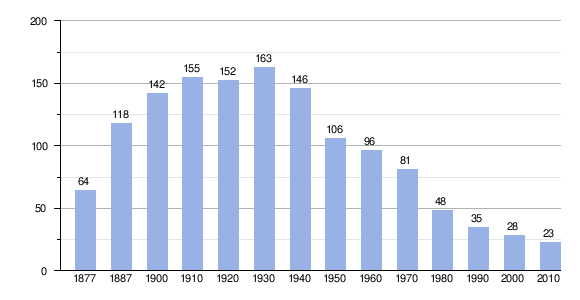
Source: INE archive - graphic processing for Wikipedia
Individual evidence
- ↑ Cifras oficiales de población resultantes de la revisión del Padrón municipal a 1 de enero . Population statistics from the Instituto Nacional de Estadística (population update).
- ↑ Roncesvalles. Retrieved December 5, 2019 .
Web links
← Previous location: Puerto de Ibañeta 1 km | Roncesvalles | Next town: Burguete 3 km →

Pilgrimage routes:
Camino de la Costa |
Camino Francés |
Camino de Liébana |
Camino Primitivo |
Camino Vasco del Interior
Main stations on the Camino Francés:
Astorga |
Burgos |
Estella |
Jaca |
León |
Logroño |
Pamplona |
Ponferrada |
Puente la Reina |
Roncesvalles |
Santiago de Compostela
2015 expansion:
Bilbao Cathedral |
Lugo Cathedral |
Mondoñedo Cathedral |
Cathedral of San Salvador with Cámara Santa |
Old Cathedral of Vitoria-Gasteiz |
San Salvador Monastery in Cornellana |
Santo Toribio de Liébana Monastery |
Sobrado Monastery |
Collegiate monastery Santillana del Mar |
Church of the Assumption of Mary in Castro Urdiales |
Puente de Briñas |
Roman city walls of Lugo |
San Salvador de Priesca |
Santa María de Soto de Luiña |
Trappist monastery Zenarruza |
San Adrián Tunnel
Abáigar | Abárzuza | Abaurregaina | Abaurrepea | Aberin | Ablitas | Adiós | Aguilar de Codés | Aibar | Allín | Allo | Alsasua | Améscoa Baja | Ancín | Andosilla | Ansoáin | Anue | Añorbe | Aoiz | Araitz | Arakil | Aranarache | Aranguren | Arano | Arantza | Macaws | Arbizu | Arce | Los Arcos | Arellano | Areso | Arguedas | Aria | Aribe | Armañanzas | Arróniz | Arruazu | Artajona | Artazu | Atez | Auritz | Ayegui | Azagra | Azuelo | Bakaiku | Barañáin | Barásoain | Barbarian | Bargota | Barillas | Basaburua | Baztan | Beintza Labaien | Beire | Belascoáin | Bera | Berbinzana | Beriáin | Berrioplano | Berriozar | Bertizarana | Betelu | Bidaurreta | Biurrun-Olcoz | Buñuel | Burgui | Burlada | El Busto | Cabanillas | Cabredo | Cadreita | Caparroso | Cárcar | Carcastillo | Cascante | Cáseda | Castejón | Castillonuevo | Cintruénigo | Cirauqui | Ciriza | Cizur | Corella | Cortes | Desojo | Dicastillo | Donamaria | Doneztebe | Echarri | Egüés | Elgorriaga | Enériz | Eratsun | Ergoiena | Erro | Eslava | Esparza de Salazar | Espronceda | Estella | Esteribar | Etayo | Etxalar | Etxarri-Aranatz | Etxauri | Eulate | Ezcabarte | Ezcároz | Ezkurra | Ezprogui | Falces | Fitero | Fontellas | Funes | Fustiñana | Galar | Gallipienzo | Gallués | Garaioa | Guard | Garínoain | Garralda | Genevilla | Goizueta | Goñi | Güesa | Guesálaz | Guirguillano | Hiriberri | Huarte | Ibargoiti | Igantzi | Igúzquiza | Imotz | Irañeta | Irurtzun | Isaba | Ituren | Iturmendi | Iza | Izagaondoa | Izalzu | Jaurrieta | Javier | Juslapeña | Lacunza | Lana | Lantz | Lapoblación | Larraga | Larraona | Larraun | Lazagurría | Leache | Legarda | Legaria | Leitza | Lekunberri | Leoz | Lerga | Lerín | Lesaka | Lezáun | Liédena | Lizoáin | Lodosa | Lónguida | Lumbier | Luquin | Luzaide / Valcarlos | Mañeru | Marañón | Marcilla | Mélida | Mendavia | Mendaza | Mendigorría | Metauts | Milagro | Mirafuentes | Miranda de Arga | Monreal | Monteagudo | Morentin | Mues | Murchante | Murieta | Murillo el Cuende | Murillo el Fruto | Muruzábal | Navascués | Nazar | Noáin | Obanos | Ochagaví | Oco | Odieta | Oitz | Oláibar | Olazti | Olejua | Olite | Ollo | Olóriz | Olza | Orbaitzeta | Orbara | Orísoain | Orkoien | Oronz | Oroz-Betelu | Orreaga | Oteiza | Pamplona | Peralta | Petilla de Aragón | Piedramillera | Pitillas | Puente la Reina | Pueyo | Ribaforada | Romanzado | Roncal | Sada | Saldias | Salinas de Oro | San Adrián | San Martín de Unx | Sangüesa | Sansol | Santacara | Sarriés | Sartaguda | Sesma | Sorlada | Sunbilla | Tafalla | Tiebas-Muruarte de Reta | Tirapu | Torralba del Río | Torres del Río | Tudela | Tulebras | Úcar | Uharte Arakil | Ujué | Ultzama | Unciti | Unzué | Urdazubi | Urdiain | Urraúl Alto | Urraúl Bajo | Urrotz | Urroz Villa | Urzainqui | Uterga | Uztárroz | Valtierra | Viana | Vidángoz | Villafranca | Villamayor de Monjardín | Villatuerta | Villava | Yerri | Yesa | Zabalza | Ziordia | Zizur Mayor | Zubieta | Zugarramurdi | Zuñiga