Capillas District
| Capillas District | |
|---|---|
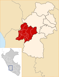
 The district of Capillas is located in the southwest of the province of Castrovirreyna (marked in red) |
|
| Basic data | |
| Country | Peru |
| region | Huancavelica |
| province | Castrovirreyna |
| Seat | Capillas |
| surface | 400 km² |
| Residents | 966 (2017) |
| density | 2.4 inhabitants per km² |
| founding | January 22, 1941 |
| ISO 3166-2 | PE-HUV |
| politics | |
| Alcalde District | Pablito José Peréz Díaz (2019-2022) |
| Political party | Movimiento Regional Ayni |
| Cajamarca in the Capillas district | |
Coordinates: 13 ° 18 ′ S , 75 ° 33 ′ W
The Capillas district is located in the Castrovirreyna province in the Huancavelica region in southwest central Peru . The district was established on January 22, 1941. It has an area of about 400 km². The 2017 census counted 966 inhabitants. In 1993 the population was 1385, in 2007 it was 1402. The seat of the district administration is the 3213 m high village Capillas with 186 inhabitants. Capillas is located 24 km west of the provincial capital Castrovirreyna .
Geographical location
The Capillas district is located in the Peruvian Western Cordillera in the southwest of the Castrovirreyna province. The Río San Juan (also Río Tantara in the upper reaches) borders the district in the northwest.
The district of Capillas borders in the south with the district Huancano ( province Pisco ), in the southwest and in the west with the districts El Carmen and Alto Larán (both in the province Chincha ), in the northwest with the district San Juan , in the northeast with the district Huachos and in the east to the Mollepampa district .
Localities
In addition to the main town, the district has the following larger towns:
- Buena Vista
- Cajamarca
- Pauranga
Web links
- Peru: Huancavelica region (provinces and districts) at www.citypopulation.de
- INEI Perú
