Castrovirreyna Province
| Castrovirreyna Province | |
|---|---|
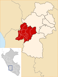
 Location of the province in the Huancavelica region |
|
| Basic data | |
| Country | Peru |
| region | Huancavelica |
| Seat | Castrovirreyna |
| surface | 3985 km² |
| Residents | 14,891 (2017) |
| density | 3.7 inhabitants per km² |
| ISO 3166-2 | PE-HUV |
| politics | |
| Alcalde Provincial | Mario Encarnación López Saldaña (2019-2022) |
| landscape | |
Coordinates: 13 ° 17 ′ S , 75 ° 19 ′ W
The province of Castrovirreyna is one of seven provinces in the Huancavelica region in southwestern Peru . The province has an area of 3985 km². At the 2017 census, 14,891 people lived in the province. In 1993 the population was 19,738, in 2007 19,500. The provincial administration is located in the small town of Castrovirreyna .
Geographical location
The province of Castrovirreyna is located about 230 km southeast of the state capital Lima . It is located in the Peruvian Western Cordillera . The San Juan and Río Pisco rivers drain the area westward to the Pacific Ocean . The longitudinal extent in SW-NE direction is about 95 km.
The province of Castrovirreyna borders in the northwest on the province Yauyos ( region Lima ), in the northeast on the province Huancavelica , in the southeast on the province Huaytará , in the south on the province Pisco ( region Ica ) and in the west on the province Chincha (also in the Region of Ica).
Administrative division
The province of Castrovirreyna is divided into 13 districts (distritos) . The Castrovirreyna district is the seat of the provincial administration.
| District | Administrative headquarters |
|---|---|
| Arma | Arma |
| Aurahuá | Aurahuá |
| Capillas | Capillas |
| Castrovirreyna | Castrovirreyna |
| Chupamarca | Chupamarca |
| Cocas | Cocas |
| Huachos | Huachos |
| Huamatambo | Huamatambo |
| Mollepampa | Mollepampa |
| San Juan | San Juan |
| Santa Ana | Santa Ana |
| Tantara | Tantara |
| Ticrapo | Ticrapo |
Web links
- Peru: Huancavelica region (provinces and districts) at www.citypopulation.de
- INEI Perú
