Ticrapo District
| Ticrapo District | |
|---|---|
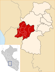
 The Ticrapo District is located in the extreme south of the Castrovirreyna Province (marked in red) |
|
| Basic data | |
| Country | Peru |
| region | Huancavelica |
| province | Castrovirreyna |
| Seat | Ticrapo |
| surface | 183 km² |
| Residents | 1560 (2017) |
| density | 8.5 inhabitants per km² |
| founding | September 6, 1920 |
| ISO 3166-2 | PE-HUV |
| politics | |
| Alcaldesa district | Sonia Margoth Balvin Acevedo (2019-2022) |
| Political party | Movimiento Independiente Trabajando para Todos |
Coordinates: 13 ° 23 ′ S , 75 ° 26 ′ W
The Ticrapo district is located in the Castrovirreyna province in the Huancavelica region in southwest central Peru . The district was founded on September 6, 1920. It has an area of 183 km². The 2017 census counted 1560 inhabitants. In 1993 the population was 2080, in 2007 it was 1795. The seat of the district administration is the 2150 m high village of Ticrapo with 983 inhabitants. Ticrapo is 16 km southwest of the provincial capital Castrovirreyna .
Geographical location
The district of Ticrapo is located in the Peruvian Western Cordillera in the extreme south of the province of Castrovirreyna. The rivers Río Chiris and Río Pisco limit the district to the west. The Río Pacococha crosses the east of the district and unites on the western district boundary with the Río Chiris to the Río Pisco.
The district of Ticrapo borders in the south on the districts San Antonio de Cusicancha and Quito-Arma (both in the province Huaytará ), in the southwest on the district Huancano ( province Pisco ), in the north-west on the district Mollepampa , in the north on the district Cocas as well to the east to the Castrovirreyna district .
Localities
In addition to the main town, the district has the following larger towns:
- Llactas
Web links
- Peru: Huancavelica region (provinces and districts) at www.citypopulation.de
- INEI Perú