Chupamarca district
| Chupamarca district | |
|---|---|
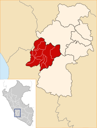
 The district of Chupamarca is located in the northwest of the province of Castrovirreyna (marked in red) |
|
| Basic data | |
| Country | Peru |
| region | Huancavelica |
| province | Castrovirreyna |
| Seat | Chupamarca |
| surface | 366 km² |
| Residents | 940 (2017) |
| density | 2.6 inhabitants per km² |
| founding | January 2, 1857 |
| ISO 3166-2 | PE-HUV |
| politics | |
| Alcalde District | Antonio Espinoza Quispe (2019-2022) |
Coordinates: 13 ° 2 ′ S , 75 ° 37 ′ W
The district of Chupamarca is located in the province of Castrovirreyna in the region of Huancavelica in the southwest of central Peru . The district was founded on January 2, 1857. It has an area of 366 km². The 2017 census counted 940 inhabitants. In 1993 the population was 950, in 2007 it was 1129. The seat of the district administration is the 3325 m high village Chupamarca with 253 inhabitants. Chupamarca is located about 42 km northwest of the provincial capital Castrovirreyna .
Geographical location
The Chupamarca district is located in the Peruvian Western Cordillera in the northwest of the Castrovirreyna province. The Río San Juan (also Río Tantara in the upper reaches) flows along the southern district boundary to the southwest and drains a large part of the area.
The district of Chupamarca is bordered in the extreme southwest by the districts of Tantara and San Pedro de Huacarpana (the latter in the province of Chincha ), in the west and northwest by the districts of Madean and Lincha (both in the province of Yauyos ), in the northeast by the districts of Acobambilla and Ascensión (both in the province of Huancavelica ) as well as in the east and in the southeast to the district of Aurahuá .
Localities
In addition to the main town, the district has the following larger towns:
- Chancahuasi
- Colcabamba
Web links
- Peru: Huancavelica region (provinces and districts) at www.citypopulation.de
- INEI Perú