Arma district
| Arma district | |
|---|---|
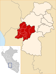
 The district of Arma is located in the central west of the province of Castrovirreyna (marked in red) |
|
| Basic data | |
| Country | Peru |
| region | Huancavelica |
| province | Castrovirreyna |
| Seat | Arma |
| surface | 301 km² |
| Residents | 1029 (2017) |
| density | 3.4 inhabitants per km² |
| founding | May 8, 1576 |
| ISO 3166-2 | PE-HUV |
| Website | muniarma.gob.pe (Spanish) |
| politics | |
| Alcalde District | José Aland Canales Abregu (2019-2022) |
| Political party | Movimiento Independiente Trabajando para Todos |
| The main town of Arma | |
Coordinates: 13 ° 8 ′ S , 75 ° 33 ′ W
The Arma district is located in the Castrovirreyna province in the Huancavelica region in southwest central Peru . The district founded on May 8, 1576 has an area of 301 km². At the 2017 census there were 1,029 residents in the district. In 1993 the population was 1567, in 2007 1504. The district administration is located in the 3336 m high village of Arma with 320 inhabitants.
Geographical location
The Arma District is located in the central west of the Castrovirreyna Province. Arma is located about 30 km northwest of the provincial capital Castrovirreyna . The district is located in the Peruvian Western Cordillera . The Río Arma, a tributary of the Río San Juan , drains the area in a south-westerly direction.
The Arma district is bordered to the west by the district Tantara , on the north by the district Aurahuá , on the east by the district Castrovirreyna and the south by the district Huachos .
Web links
- Municipalidad Distrital de Arma
- Peru: Huancavelica region (provinces and districts) at www.citypopulation.de
- INEI Perú
