Río Pisco
| Río Pisco | ||
|
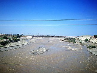
Río Pisco near San Clemente |
||
| Data | ||
| location |
|
|
| River system | Río Pisco | |
| Confluence of | Río Chiris and Río Pacococha 13 ° 25 ′ 50 ″ S , 75 ° 27 ′ 51 ″ W |
|
| Source height | approx. 1700 m | |
| muzzle |
Pacific Ocean Coordinates: 13 ° 41 ′ 18 ″ S , 76 ° 13 ′ 17 ″ W 13 ° 41 ′ 18 ″ S , 76 ° 13 ′ 17 ″ W |
|
| Mouth height | 0 m | |
| Height difference | approx. 1700 m | |
| Bottom slope | approx. 16 ‰ | |
| length | approx. 106 km (including Río Chiris: 186 km) | |
| Catchment area | 4,434.5 km² | |
| Discharge at the Letrayoc gauge. Location: 55 km above the estuary |
MQ |
25.68 m³ / s |
| Left tributaries | Río Jallin Rumichaca | |
| Small towns | San Clemente | |
The Río Pisco is an approximately 106 km (including Río Chiris : 186 km) long tributary of the Pacific Ocean in the southwest of Peru in the regions of Huancavelica and Ica .
River course
The Río Pisco arises in the Peruvian Western Cordillera at an altitude of about 1700 m near the town of Ticrapo at the confluence of the Río Chiris (right) and Río Pacococha (left). The main source river is the 80 km long Río Chiris. Its origin is the 4690 m high lake Laguna Pultoc Grande ( ⊙ ). The Río Pisco flows through the mountains over a length of about 60 km, initially 25 km in a south-south-west direction, later in a west-south-west direction. In the lower 45 kilometers, the river crosses the arid, desert-like coastal plain in a westerly direction. It is bordered by irrigated agricultural areas. The Panamericana Sur crosses the river near the small town of San Clemente , about 8 kilometers above the estuary . At the lower reaches of the Río Pisco there are several weirs at which irrigation channels branch off. The river carries very little water for the last few kilometers. It finally reaches the Pacific coast north of the provincial capital Pisco . There it flows into a lagoon, which is almost completely separated from the sea by a sandbank.
Catchment area and hydrology
The catchment area of the Río Pisco covers an area of 4434.5 km². In the north the catchment area borders on that of the Río San Juan , in the south on that of the Río Ica . The mean discharge at the Letrayoc gauge ( ⊙ at river kilometer 55, located at an altitude of 630 m ) is 25.68 m³ / s. During the rainy season, the river carries most of the water in the year.
![]() Map with all coordinates: OSM | WikiMap
Map with all coordinates: OSM | WikiMap
ecology
In the Río Pisco, the shrimp species Cryphiops caementarius from the family of rock and partner shrimp (Palaemonidae) occurs.
Individual evidence
- ↑ a b c d Evaluation y Ordenamiento de los Recursos Hidricos de la Cuenca del Rio Pisco (PDF, 5.8 MB) Ministerio de Agricultura, Instituto Nacional de Recursos Naturales (INRENA). July 2003. Retrieved September 27, 2019.
- ^ Camarón del Rio . Instituto del Mar del Peru - IMARPE. Retrieved September 25, 2019.
