Torquemada (Palencia)
| Torquemada parish | ||
|---|---|---|
 Torquemada - Bridge over the Río Pisuerga and Iglesia de Santa Eulalia
|
||
| coat of arms | Map of Spain | |

|
|
|
| Basic data | ||
| Autonomous Community : |
|
|
| Province : | Palencia | |
| Comarca : | El Cerrato | |
| Coordinates | 42 ° 2 ′ N , 4 ° 19 ′ W | |
| Height : | 755 msnm | |
| Area : | 83.63 km² | |
| Residents : | 954 (Jan. 1, 2019) | |
| Population density : | 11.41 inhabitants / km² | |
| Postal code : | 34230 | |
| Municipality number ( INE ): | 34182 | |
| administration | ||
| Website : | Torquemada | |
Torquemada (= "burnt tower") is a place and a northern Spanish municipality (municipio) with only 954 inhabitants (as of January 1, 2019) in the province of Palencia of the Autonomous Community of Castile-León .
The name of the former small town is associated with Tomás de Torquemada (1420–1498), a Dominican monk and first Grand Inquisitor of Spain, but also his uncle, the theologian Juan de Torquemada (around 1388–1468), has this suffix, although both were born in Valladolid were.
Location and climate
The place Torquemada is located in the old Castilian Meseta on the Río Pisuerga about 2 km southwest of the confluence of the Río Arlanza at an altitude of about 755 m . The provincial capital Palencia is a good 23 km (driving distance) to the west; the cities of Burgos and Valladolid are approx. 70 km to the northeast and 60 km to the south-west, respectively. The climate in winter is cool, in summer, despite the altitude, it is temperate to warm; Precipitation (approx. 460 mm / year) falls mainly in the winter half-year.
Population development
| year | 1857 | 1900 | 1950 | 2000 | 2018 |
| Residents | 2,840 | 2,957 | 2,727 | 1,176 | 968 |
The significant population decline that began around the middle of the 20th century is essentially due to the mechanization of agriculture and the abandonment of small farms and the resulting loss of jobs ( rural exodus ).
economy
In earlier times, the residents of the place and the entire region lived almost without exception as self-sufficient on the yields of their fields and house gardens; also viticulture and livestock were operated. Centuries ago, small traders, craftsmen and service providers of all kinds settled in the town itself, but many of them gave up their business due to the enormous decline in population. The municipality of Torquemada is now part of the Arlanza (DO) wine-growing region .
history
Written or archaeological evidence from the Celtic , Roman , Visigothic and even Moorish times is largely missing, although the foundations of two late Roman country estates ( villae rusticae ) have been discovered in the municipality . In the late 9th century, the area was occupied by the Christians under the leadership of the Asturian King Alfons III. recaptured. Later, the history of the place was closely linked to that of Palenzuela, just 9 km to the north . In the 15th century, the administrative area of the Merindad de Cerrato emerged with Palenzuela as the main town. In the years 1520 to 1542, Emperor Charles V visited the city several times, which was given a new and for the time enormously long stone bridge over the Río Pisuerga between 1583 and 1586.
Attractions
- The 25-arched and 150 m long stone bridge over the Río Pisuerga is the most important structure in the former city. They and their wooden predecessors made it possible for humans and animals to cross the river, which is difficult because it leads through marshy banks. The bridge was repaired several times in the following centuries.
- The three-aisled Iglesia de Santa Eulalia in its current form as a hall church dates from the 16th century. The former bundle pillars were converted into round pillars in the 17th or 18th century ; the late Gothic acting stellar vault , however, remained untouched. The altars were made in the 18th or 19th centuries. It is remarkable that the imposing church has no tower, only a bell gable (espadaña) .
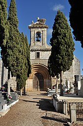
- The Iglesia de Santa Cruz , which is also three-aisled , has a Romanesque , but not figurative archivolt portal . Later the church was repeatedly rebuilt and the portal is surmounted by a baroque bell gable.
- Surroundings
- Approx. The Santuario de Nuestra Señora De Valdesalce is located 3.5 km northwest of the village . The church, which may belong to a former hamlet, has a Gothic apse , but otherwise corresponds to later stylistic epochs.
Personalities
- Catherine of Castile (1507–1578), Infanta of Castile and later Queen of Portugal , was born in Torquemada.
Web links
Individual evidence
- ↑ Cifras oficiales de población resultantes de la revisión del Padrón municipal a 1 de enero . Population statistics from the Instituto Nacional de Estadística (population update).
- ↑ Torquemada - Climate tables
- ↑ Torquemada - Population Development
- ↑ Torquemada - History
- ↑ Torquemada Bridge
- ↑ Torquemada - Church of Santa Eulalia
- ↑ Torquemada - Santa Cruz Church
- ↑ Torquemada - Santuario

