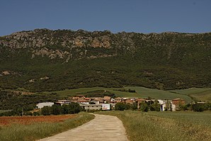
Navas de Bureba
| Navas de Bureba municipality | ||
|---|---|---|
 Navas de Bureba - Church of San Blas
|
||
| coat of arms | Map of Spain | |

|
|
|
| Basic data | ||
| Autonomous Community : |
|
|
| Province : | Burgos | |
| Comarca : | La Bureba | |
| Coordinates | 42 ° 41 ′ N , 3 ° 20 ′ W | |
| Height : | 770 msnm | |
| Area : | 8.79 km² | |
| Residents : | 33 (Jan. 1, 2019) | |
| Population density : | 3.75 inhabitants / km² | |
| Postal code : | 09249 | |
| Municipality number ( INE ): | 09230 | |
| administration | ||
| Website : | Navas de Bureba | |
Navas de Bureba is a northern Spanish town and a rural municipality ( municipio ) with only 33 inhabitants (as of January 1, 2019) in the province of Burgos in the autonomous community of Castile-León .
Location and climate
The place Navas de Bureba lies at the foot of the Montes Obarenes on the northern edge of the La Bureba region at an altitude of about 770 m . The provincial capital Burgos is a good 63 km (driving distance) to the southwest; Briviesca , the capital of the region, is about 18 km south. The climate in winter is harsh, but in summer it is temperate and warm; the rain, which is abundant by Spanish standards (approx. 740 mm / year), falls mainly in the winter months.
Population development
| year | 1857 | 1900 | 1950 | 2000 | 2017 |
| Residents | 219 | 152 | 151 | 51 | 34 |
The mechanization of agriculture and the closure of smaller farms have led to a loss of jobs and thus to a migration of people to the larger cities ( rural exodus ) since the middle of the 20th century .
economy
For centuries, the inhabitants of the community lived mainly from agriculture (agriculture, viticulture and small livestock farming) as a self-sufficient living ; only since the middle of the 20th century has it been produced for the national market. Tourism in the form of rental of holiday homes (casas rurales) has also played a certain role in the municipality's income since the 1960s.
history
The landscape of the Bureba was already known to the people of the Stone Age and ancient times as a much-used connecting route; Celts from the tribe of the Autrigones settled here and the Romans called their later settlement near the present-day Monasterio de Rodilla Tritium Autrigonum . In the 8th and early 9th centuries, the area was under Islamic influence, but the area was neither permanently settled nor defended by the Berbers due to the unusually harsh and rainy climate . At the end of the 9th century, the Castilian Count Diego Rodríguez Porcelos received from King Alfons III. of Asturias the order to repopulate ( repoblación ) the depopulated area. The town was founded at this time and was first mentioned in a document in 1011.
Attractions
- The single nave Iglesia de San Blas dates from the 12th / 13th centuries. Century; due to the complex structural columns outline and stone processing with zigzag friezes , figurative capitals , Konsolfiguren and frequent Pass - blind arches in the area of the choir and the apse it might originally a priory have acted. The transverse bell gable (espadana) that towers above the church above the Romanesque archivolt portal on the south side is a later addition; it partially collapsed in May 2014. The nave (nave) is vaulted , plastered and painted with joints ; the fore choir yoke is covered by a pointed barrel, the apse shows the usual dome vault .
- Surroundings
- In the adjacent nature park of the Montes Oberenes there are numerous hiking opportunities and opportunities to observe nature.
Web links
- Navas de Bureba - Photos + Info (Spanish)
Individual evidence
- ↑ Cifras oficiales de población resultantes de la revisión del Padrón municipal a 1 de enero . Population statistics from the Instituto Nacional de Estadística (population update).
- ↑ Navas de Bureba - climate tables
- ↑ Navas de Bureba - population development
- ↑ Navas de Bureba - History
- ↑ Navas de Bureba - Church
- ↑ Navas de Bureba - Church

