Aguilar de Bureba
| Aguilar de Bureba municipality | ||
|---|---|---|
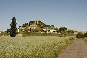
 Aguilar de Bureba - town view
|
||
| coat of arms | Map of Spain | |

|
|
|
| Basic data | ||
| Autonomous Community : |
|
|
| Province : | Burgos | |
| Comarca : | La Bureba | |
| Coordinates | 42 ° 35 ′ N , 3 ° 20 ′ W | |
| Height : | 690 msnm | |
| Area : | 9.45 km² | |
| Residents : | 58 (Jan. 1, 2019) | |
| Population density : | 6.14 inhabitants / km² | |
| Postal code : | 09249 | |
| Municipality number ( INE ): | 09007 | |
| administration | ||
| Website : | Aguilar de Bureba | |
Aguilar de Bureba is a place and a northern Spanish rural municipality ( municipio ) with only 58 inhabitants (at January 1, 2019) in the province of Burgos in the autonomous community of Castile and Leon .
Location and climate
The place Aguilar de Bureba is located on the Río Anguilas, a tributary of the Río Oca , at an altitude of about 690 m on the "Corridor of La Bureba ", a connection between the upper Ebro Valley and the landscapes of the Duero, which was already used in the Stone Age . The provincial capital Burgos is about 50 km (driving distance) to the southwest; Briviesca , the next larger town, is approx. 5 km to the south. The climate in winter is harsh, but in summer it is temperate and warm; Rain (approx. 690 mm / year) falls mainly in the winter half-year.
Population development
| year | 1857 | 1900 | 1950 | 2000 | 2017 |
| Residents | 286 | 261 | 225 | 86 | 60 |
The mechanization of agriculture and the closure of smaller farms have led to a loss of jobs and thus to an exodus of people to the larger cities ( rural exodus ) since the 1950s .
economy
For centuries, the inhabitants of the community lived mainly from agriculture (agriculture, viticulture and small livestock farming) as a self-sufficient living ; only since the middle of the 20th century has it been produced for the national market. Tourism in the form of rental of holiday homes (casas rurales) has also played a certain role in the municipality's income since the 1960s.
history
The surroundings of the place were already known to the people of the Stone Age and Antiquity as a widely used connection route; Celts from the Autrigone tribe settled here, but neither they nor the Romans or the Visigoths left any traces. In the 8th and early 9th centuries, the area was under Islamic influence, but the area was neither permanently settled nor defended due to the unusually harsh climate. At the end of the 9th century, the Castilian Count Diego Rodríguez Porcelos received from King Alfons III. of Asturias the order to repopulate ( repoblación ) the depopulated area with Christians from the north or south of the Iberian Peninsula . The first mention of the place name can be found in the cartularios of the monastery of San Salvador of Oña from the 10th or 11th century.
Attractions
The Iglesia Santa María la Mayor or Iglesia de la Asunción de Nuestra Señora , located on the top of a small hill, originally dates from the 12th century; however, it was slightly changed repeatedly in later times. The Romanesque apse is structured by pillars and pillars. The five-arched bell gable (espadaña) dates from the Baroque period . The Romanesque portal protected by a vestibule shows an alternation between white and red stones. The single-nave church has a transept ; the crossing dome is illuminated by a later placed lantern . Several capitals both outside and inside the church show mythical creatures. The furnishings include several baroque altarpieces (retablos) .
Web links
- Aguilar de Bureba - Photos + Info (wikiburgos, Spanish)
Individual evidence
- ↑ Cifras oficiales de población resultantes de la revisión del Padrón municipal a 1 de enero . Population statistics from the Instituto Nacional de Estadística (population update).
- ↑ Aguilar de Bureba - climate tables
- ↑ Aguilar de Bureba - population development
- ↑ Aguilar de Bureba - History
- ↑ Aguilar de Bureba - Church
- ↑ Aguilar de Bureba - Church

