Pedrafita do Cebreiro
| Pedrafita do Cebreiro municipality | ||
|---|---|---|
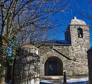
 O Cebreiro - Igrexa de Santa María a Real
|
||
| coat of arms | Map of Spain | |

|
|
|
| Basic data | ||
| Autonomous Community : | Galicia | |
| Province : | Lugo | |
| Comarca : | Los Ancares | |
| Coordinates | 42 ° 44 ′ N , 7 ° 1 ′ W | |
| Height : | 1100 msnm | |
| Area : | 105.10 km² | |
| Residents : | 1.001 (Jan. 1, 2019) | |
| Population density : | 9.52 inhabitants / km² | |
| Postal code : | 27670 | |
| Municipality number ( INE ): | 27045 | |
| administration | ||
| Website : | www.concellodepedrafitadocebreiro.es | |
Pedrafita do Cebreiro is a municipality ( municipio ) in northwestern Spain with 1001 inhabitants (as of January 1, 2019) in the province of Lugo in the autonomous community of Galicia . The municipality owns several villages, of which O Cebreiro is best known because it is the Spanish Way of St. James ( Camino Francés is located).
location
The large municipality of Pedrafita do Cebreiro is located in the east of the province of Lugo near the border with the province of León in the autonomous community of Castile and León at an altitude of about 1100 to 1350 meters above sea level. d. M. The provincial capital Lugo is about 70 kilometers (driving distance) to the northwest; to Santiago de Compostela it is about 144 kilometers on foot or about 180 kilometers by car.
Community structure
|
|
Population development of the municipality

In the 19th century the community consistently had over 4,000 inhabitants. The mechanization of agriculture and the associated loss of jobs have led to a persistent decline in population since then.
economy
For centuries, Pedrafita do Cebreiro was one of several villages and hamlets in the vicinity of the strategically and commercially important Cebreiro Pass , which forms the transition between the rather dry plateaus ( mesetas ) of Castile-León and the more mountainous and rainy landscapes of Galicia. The residents lived mainly as a self-sufficient living from agriculture, whereby agriculture and cattle breeding (milk and cheese) were equally important. Due to the location on the Spanish Way of St. James, tourism now also plays a certain role in the economic life of the population.
history
The path over the Cebreiro Pass was already used in ancient times; he formed the connection from Triacastela to Astorga ( Asturica Augusta ). Pilgrimages to the tomb of the apostle James began in the 9th century, but did not experience their heyday until the 11th and 12th centuries. In 836, the Asturian King Alfonso II founded a pilgrim hospital in O Cebreiro. 650 years later (1486) the Catholic Kings Isabella and Ferdinand made a pilgrimage to Santiago and stayed overnight in O Cebreiro.
Attractions
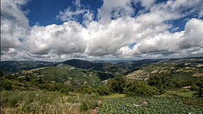
Apart from the surrounding mountain landscape and some houses built from rubble stones, the place itself offers no sights. These are all located in O Cebreiro .
Web links
- Pedrafita do Cebreiro, history - photos + brief information (Spanish)
- Pedrafita do Cebreiro, history - information (spanish)
Individual evidence
- ↑ Cifras oficiales de población resultantes de la revisión del Padrón municipal a 1 de enero . Population statistics from the Instituto Nacional de Estadística (population update).


