Shkëlzen
| Shkëlzen | ||
|---|---|---|
|
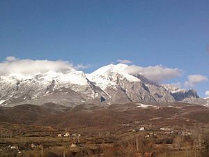
South side of the Shkëlzen |
||
| height | 2407 m above sea level A. | |
| location | Albania | |
| Mountains | North Albanian Alps | |
| Dominance | 7.2 km → Maja e Zezë | |
| Coordinates | 42 ° 27 '26 " N , 20 ° 7' 42" E | |
|
|
||
| Type | Rock peaks | |
| rock | limestone | |
| Normal way | West ridge | |
|
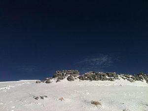
Holy grave on the summit |
||
|
View down to Bajram Curr and the surrounding area |
||
The Shkëlzen ( Albanian Mali i Shkëlzenit ) is a mountain in the Albanian Alps in northeastern Albania . With a height of 2407 m above sea level. A. it is one of the highest mountains in Albania. It forms the south-eastern end of the Malësia e Vogël, the eastern part of the Albanian Alps, and dominates the Tropojas landscape , towering over the Tropoja basin by 2000 meters.
The Shkëlzen is part of a mountain range that begins west of the summit with Mount Radesha ( 2313 m above sea level ). The chain stretches north from Shkëlzen and reaches the highest altitude in Maja e Zezë around seven kilometers further north at 2,425 m above sea level. A. To the north and west, the mountain range is bounded by the valley of the Gash , a tributary of the Valbona . To the east, the valley of the Tropoja stream separates the Shkëlzen from the Đeravica ( 2656 m. I. J. ), the highest mountain in the region. Gash and Tropoja Bach originate in a region with various mountain lakes on the Dobërdol Pass (approx. 2238 m above sea level ) with the Dash lake and the Alm Dobërdol in the north and the Sylbica lakes in the south. They pass the mountain in deep gorges that hardly allow access to the practically uninhabited mountainous region north of the mountain range. The area north of the mountain to the border is part of the Lugina e Gashit nature reserve (Valley of the Gash) .
At Shkëlzen there are alpine pastures up to great heights of almost 2000 meters. Beeches can be found up to a height of around 1800 meters, and armored pine above that . The limestone mountain range is characterized by numerous karst and glacial forms.
South of the summit of the Radesha at the entrance to the Gash gorge is the village of Skëlzen at approx. 950 m above sea level. A. On the southern slope there are other settlements and villages, including the village of Tropoja ( 378 m above sea level ). Bajram Curr is a little further west, on the right of the Vjosa.
The Shkëlzen is a holy mountain for the believers in the region. There is a grave on its summit, which is visited by pilgrims on August 7th. No one is buried there, but the place is said to have wonderful healing powers.
Web links
- Video from the summit (Twitter)
Remarks
- ↑ In the military map 1: 50,000 "K-34-53-C Bajram Curri" (2nd edition, Tirana 1988) is a height of 2405.2 m above sea level. A. noted.
Individual evidence
- ↑ a b c Akademia e Shkencave e RPSSH (ed.): Fjalor enciklopedik shqiptar . tape 2 . Tirana 1985, Vargmalet midis luginës së Gashit e asaj të Tropojës, p. 90-92 .
- ↑ Military map 1: 50,000 "K-34-53-C Bajram Curri". 2nd edition, Tirana 1988.
- ↑ Zeqir Lushaj: Shtëpia e Zotit. In: Zemra Shqiptare. August 13, 2012, accessed August 9, 2016 (Albanian).
- ↑ Një udhëtim në bjeshkët e Tropojës. In: Ylli Press. July 31, 2012, accessed August 9, 2016 (Albanian).


