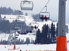
Rusiń-ski ski area
The Rusiń-ski ski area is located on the summit and the southern slopes of Rusiński Wierch in the Polish mountain range Pogórze Bukowińskie in the municipality of Bukowina Tatrzańska in the powiat Tatrzański in the Lesser Poland Voivodeship . It is located outside the Tatra National Park at the foot of the High Tatras . The ski area is operated by the company Rusiń-ski Sp. Z oo. Together with other ski areas in the Bukowina Tatrzańska municipality, it is part of the Tatra Ski alliance under one ski pass.
location
The ski area is located at an altitude of 807 m above sea level to 933 m above sea level. The difference in altitude between the slopes is approx. 126 m. There are three red (difficult), two blue and one green slopes. The total length of the slopes is approximately 4.4 km, with the longest slope being 1.3 km long.
history
The ski area was created in 2005. The ski lift went into operation in 2009. The second chairlift was built in 2015.
description
Ski lifts
There are two chair lifts and three button lifts in the ski area. A total of up to 6100 people can be transported per hour.
Rusiń-ski ski lifts
The ski lifts lead from Bukowina Tatrzańska to just below the summit of Rusiński Wierch . Their lengths are up to 1150 m.
| Surname | Art | Manufacturer | Broad people | Length (m) | Time (min) | Height difference (m) | People per hour | Upper station | Lower station | Vmax (m / s) |
||
|---|---|---|---|---|---|---|---|---|---|---|---|---|
| place | Height (m above sea level) | place | Height (m above sea level) | |||||||||
| A, K1 | Chairlift | Doppelmayr / Garaventa Group | 4th | 700 | 124 | 2400 | Upper station | 933 | Lower station | 807 | ||
| B. | Button lift | 1 | 400 | 700 | ||||||||
| C. | Button lift | 1 | 200 | 300 | ||||||||
| D. | Chairlift | Bartholet Maschinenbau AG | 6th | 1150 | 2700 | |||||||
| Baby lift | tape | 80 | ||||||||||
Ski slopes
Six ski slopes lead from the Rusiński Wierch into the valley, three red, two blue and one green slopes.
| Surname | difficulty | begin | target | Length (m) | Height difference (m) | Tilt (%) | light | Artificial snow | FIS | Remarks | |||
|---|---|---|---|---|---|---|---|---|---|---|---|---|---|
| Surname | Height (m above sea level) | Surname | Height (m above sea level) | number | to | ||||||||
| 1 | red | Upper station | 933 | Lower station | 807 | 900 | 124 | 14th | Yes | Yes | |||
| 2 | blue | Upper station | 933 | Lower station | 813 | 400 | 120 | 30th | Yes | Yes | |||
| 3 | blue | Upper station | 933 | Lower station | 807 | 850 | 126 | 15th | Yes | Yes | |||
| 4th | red | Upper station | 933 | Lower station | 807 | 850 | 126 | 15th | Yes | Yes | |||
| 5 | blue | Upper station | 933 | Lower station | 883 | 200 | 50 | 25th | Yes | Yes | |||
| 6th | red | Upper station | 933 | Lower station | 807 | 1200 | 124 | Yes | Yes | ||||
Infrastructure
The ski area is about 10 km northeast of the center of Zakopane and can be reached by car. A municipal road runs near the upper station. There are parking spaces, a ski school and ski rental there. There are also several restaurants in the ski area.
See also
- Bania ski area
- Kaniówka ski area
- Kotelnica ski area
- Turnia ski area
- Grapa-Litwinka ski area
- Koziniec ski area
- Jurgów ski area
- List of ski resorts in Poland
Web links
Coordinates: 49 ° 21 ′ 9 ″ N , 20 ° 5 ′ 53 ″ E


