Slauharad
| Slauharad | Slavgorod | |||
| Слаўгарад | Славгород | |||
| ( Belarus. ) | ( Russian ) | |||
|
|||
| State : |
|
||
| Woblasz : |
|
||
| Coordinates : | 53 ° 27 ' N , 31 ° 0' E | ||
| Height : | 137 m | ||
| Residents : | 8,300 (2009) | ||
| Time zone : | Moscow time ( UTC + 3 ) | ||
| Telephone code : | (+375) +375 802246 | ||
| Postal code : | 213245, 213240 | ||
| License plate : | 6th | ||
|
|
|||
Slauharad ( Belarusian Слаўгарад ; Russian Славгород / Slawgorod ) is a city in Belarus and the administrative center of the administrative unit Slauharad Rajon .
geography
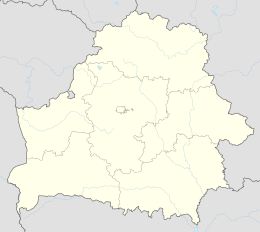
It is located in Mahiljouskaja Woblasz and lies on the Sosh River . A little further to the southeast lies Krasnapolle .
history
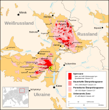
The city was called Propoisk until 1945. In 1986 the area around Slauharad was radioactively contaminated by the Chernobyl nuclear disaster .
Sons of the place
- Arthur Lourié (1891–1966), Russian composer
- Sachari Tschernjakow (1900–1997), Soviet Finnougrist, ethnologist and linguist
literature
- Propoysk , in: Guy Miron (Ed.): The Yad Vashem encyclopedia of the ghettos during the Holocaust . Jerusalem: Yad Vashem, 2009 ISBN 978-965-308-345-5 , p. 613
Web links
Commons : Slaŭharad - collection of images, videos and audio files


