Socorro (Oriental Mindoro)
| Municipality of Socorro | ||
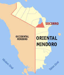
| Location of Socorro in the Oriental Mindoro Province | ||
|---|---|---|

|
||
| Basic data | ||
| Region : | MIMAROPA | |
| Province : | Oriental Mindoro | |
| Barangays : | 26th | |
| District: | 1. District of Oriental Mindoro | |
| PSGC : | 175214000 | |
| Income class : | 3rd income bracket | |
| Households : |
May 1, 2000 census
|
|
| Population : | 39,099 August 1, 2015 census
|
|
| Population density : | 258.3 inhabitants per km² | |
| Area : | 151.38 km² | |
| Coordinates : | 13 ° 4 ′ N , 121 ° 25 ′ E | |
| Postal code : | 5207 | |
| Geographical location in the Philippines | ||
|
|
||
Socorro is a Filipino municipality in the province of Oriental Mindoro , in the administrative region IV-B, Mimaropa. It has 39,099 inhabitants (August 1, 2015 census) who lived in 26 barangays . It is classified as a third income class community in the Philippines and as partially urbanized .
The topography of the municipality is characterized by flat, hilly terrain. Parts of Lake Naujan National Park are on the territory of the municipality. Their neighboring communities are Pola in the east, Victoria in the west and Pinamalayan in the south.
Barangays
|
|
