Sonnenberg (Braunlage)
|
Sonnenberg
City of Braunlage
Coordinates: 51 ° 45 ′ 38 " N , 10 ° 30 ′ 48" E
|
||
|---|---|---|
| Height : | 780 m above sea level NN | |
| Postal code : | 37444 | |
|
Location of Sonnenberg in Lower Saxony |
||
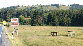
Sonnenberg is a district of the town of Braunlage in the Goslar district in Lower Saxony .
The Sonnenberg
In the vicinity of the district are the Große (853.4 m above sea level) and the Kleine Sonnenberg (853.0 m above sea level). The district is named after them.
There are several winter sports areas on the slopes of the Sonnenberge , most of which can be reached from the settlement's parking lots.
Transport links
Sonnenberg is connected to the Großer Sonnenberg and the Kleiner Sonnenberg via state road 519 . In addition, the federal highway 242 runs through the village and leads to Braunlage in the southeast .
history
The origin of the settlement goes back to the Sonnenberger Wegehaus, which was used as a guesthouse and lodging house even before the First World War.
Today there are about seven properties here, although the two restaurants have mostly been closed for several years, among the other buildings there are few residential buildings, but rather buildings for skiing and group quarters.
Until November 1, 2011, Sonnenberg still belonged to the mining town of Sankt Andreasberg , with the incorporation of these, Sonnenberg became a district of the town of Braunlage .
Hans-Dieter Harnisch House
The former Sonnenberger Wegehaus of the Harz Club branch association Hanover is located in Sonnenberg . In this house, Hans-Dieter Harnisch, as the main path master of the Harz Club , produced up to 3,000 signs per year for 40 years, with which the Harz hiking trail network was signposted in an exemplary manner. Compared to the much larger and more expensive signposts of the national park, the Harz Club signs have the advantage of better durability and visibility in the dark. Hans-Dieter Harnisch received the Federal Cross of Merit in 2001 for his services to the Harz road network . When he died unexpectedly in 2003, the Sonnenberger Wegehaus was renamed the Hans-Dieter-Harnisch-Haus in his honor. Hans-Dieter Harnisch found his final resting place in the Sankt Andreasberg cemetery.
International House Sonnenberg
About three kilometers south of the "Sonnenberg" settlement is the "Internationales Haus Sonnenberg" conference center, which is much closer to the Sankt Andreasberg district and does not belong to the "Sonnenberg" district.
The operator Sonnenberg-Kreis eV is an independent provider of international, extracurricular educational work in Europe, it pursues exclusively and directly non-profit purposes. In the "Internationales Haus Sonnenberg" conference center, which was inaugurated in 1953, events are held throughout the year, primarily on topics relating to political education. The events are often international, so that participants from different countries can work together and exchange ideas.
In August 2014, the Sankt Andreasberg observatory was opened in House A. It is the highest observatory in northern Germany. With a location 710 meters above sea level , it is one of the six best star observation locations in Germany.
Between the Sonnenberg settlement and the International Haus Sonnenberg lie the “Große” and the “Kleine Sonnenberg”, on the drive over the L 519 you cross the 830 m high saddle between these two mountains.
Web links
Individual evidence
- ↑ Twenty-year anniversary of the project Long-term Effects of National Socialism - a series by the International Haus Sonnenberg eV Federal Agency for Civic Education, accessed on March 26, 2019.
- ↑ Homepage: Internationales Haus Sonnenberg (as of 11/2014)
- ^ The highest observatory in the north in St. Andreasberg ( Memento from June 29, 2015 in the Internet Archive ), website of Sat1 Regional Hannover, accessed on April 12, 2015


