
Sonnenberg (Harz)
| Great Sonnenberg | ||
|---|---|---|
 North side of the Great Sun Mountain |
||
| height | 853.4 m above sea level NHN | |
| location | near Sonnenberg ; District of Goslar , Lower Saxony ( Germany ) | |
| Mountains | resin | |
| Dominance | 1.95 km → Rehberg | |
| Notch height | 23 m | |
| Coordinates | 51 ° 45 ′ 20 " N , 10 ° 30 ′ 47" E | |
|
||

| Little sun mountain | |
|---|---|
| height | 853 m above sea level NHN |
| location | near Sonnenberg ; District of Goslar , Lower Saxony ( Germany ) |
| Mountains | resin |
| Dominance | 0.9 km → Rehberg |
| Notch height | 20 m |
| Coordinates | 51 ° 44 ′ 59 " N , 10 ° 31 ′ 53" E |
The Sonnenberg , also called (the) Sonnenberge , is an elevation on the high elevations of the Harz low mountain range in the non-parish Harz region of the Goslar district in Lower Saxony . It is part of the Upper Harz , lies in the Harz National Park and consists of the Großer Sonnenberg ( 853.4 m above sea level ) and the Kleiner Sonnenberg ( 853 m ). A winter sports area extends over it .
geography
location
The Sonnenberge rise in the Harz National Park : The northwestern Große Sonnenberg is located about 5 km north of Sankt Andreasberg , a west-southwestern district of Braunlage . To the north of its crest is the Sonnenberg settlement (approx. 780 m ), a north-western part of Braunlage. About 1 km southeast of the Großer Sonnenberg is the Kleine Sonnenberg , which is only 0.4 m lower . To the west the landscape falls into the valley of the Sieber , there called the Great Sun Valley , and to the east into that of the Oder ; Both rivers are fed by streams from the Sonnenberge. Two valleys to the south and southwest of the Kleiner Sonnenberg are called Großes Sonnental and Kleines Sonnental , through which the small tributaries of the small Fischbach tributary flow.
Natural allocation
The Sonnenberge belong in the natural spatial main unit group Harz (No. 38) and in the main unit Hochharz (381) to the subunit Torfhäuser Hügelland (381.1). To the north to northwest the landscape leads over into the subunit Acker-Bruchberg-Ridge (381.2). To the west it descends in the main unit Südlicher Oberharz ( Südlicher Mittelharz ; 380.8) in the subunit Sieberbergland (380.82) and to the south in the subunit Andreasberger plateau (380.83).
Mountain height and trigonometric point
On the eastern slope of the Großer Sonnenberg, which is 853.4 m high, there is a trigonometric point at 838 m , the height of which, which can usually be found in topographic maps , is often misinterpreted as the height of the Großer Sonnenberg.
Protected areas
Parts of the fauna-flora-habitat area of the Harz National Park (Lower Saxony) (FFH no. 4129-302; 157.7 km² ) are located on the Sonnenberge . Large parts of the mountains are located in the Harz National Park bird sanctuary (VSG no. 4229-402; 155.59 km²).
traffic
Over the 830 m high saddle between the Großer and Kleiner Sonnenberg, the state road 519 runs between the Sonnenberg settlement, with its connection to the federal road 242 , and the mountain town of Sankt Andreasberg, with its connection to the L 520; this saddle has the highest street point of all public roads in northern Germany.
Winter sports area
| Sonnenberg Harz | |
| place |
|
| mountain | Big Sun Mountain, Little Sun Mountain |
| Coordinates | 51 ° 45 ′ 29 " N , 10 ° 30 ′ 43" E |
| Lifts |
|
| Website | sonnenbergharz.de |
|
|
|
|---|---|
| begin | Mountain station pony lift |
| target | Pony lift valley station |
|
|
|
| begin | Großer Sonnenberg mountain station |
| target | Großer Sonnenberg valley station |
| Height difference | 60 hm. |
|
|
|
| begin | Junction (blue slope) |
| target | Großer Sonnenberg valley station |
|
|
|
| begin | Großer Sonnenberg mountain station |
| target | Großer Sonnenberg valley station |
| Height difference | 60 hm. |
|
|
|
| begin | Sonnenhang mountain station |
| target | Sonnenhang valley station |
| Height difference | 40 hm. |
|
|
|
| begin | Sonnenhang mountain station |
| target | Sonnenhang valley station |
| Height difference | 40 hm. |
|
|
|
| begin | Kleiner Sonnenberg mountain station |
| target | Kleiner Sonnenberg valley station |
| Height difference | 62 m. |
To ski
There are three drag lifts and a pony lift for alpine sports on the Sonnenberge.
- Difficulty level: 1400 m easy; 1200 m medium
- Total length of the slopes: 2600 m
The slopes in the Sonnenberg ski area are not allowed to have artificial snow , as the ski area is located in the Harz National Park .
Cross-country skiing
For cross-country skiers, the Sonnenberg trail network offers a direct connection to the Sankt Andreasberg trails. There is also a connection to the Ackerloipe and a connecting trail to Oderbrück , which leads past the Oderteich . There is a separate toboggan run for tobogganers. For the mountain rescue service, there is an accident help center of the mountain rescue service Sankt Andreasberg in the large car park, which is occupied on the winter weekends. Due to the altitude, the Sonnenberg is snow-sure until spring.
The state biathlon center is also located on the Sonnenberg , where national and international competitions are held. In 2009 a snowmaking system was built.
gallery

View from a distance of the northeast slope of the little one
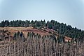
and the Great Sun Mountain

North side of the Großer Sonnenberg; left the federal road 242
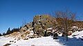
Summit rocks of the Großer Sonnenberg

Trail on the Großer Sonnenberg

View from the Großer Sonnenberg to the north of the settlement
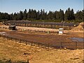
Shooting range of the biathlon facility


Web links
Individual evidence
- ↑ a b c d e f Map services of the Federal Agency for Nature Conservation ( information )
- ↑ a b Skistadion Sonnenberg , on oberharz.de
- ↑ Bergwacht Sankt Andreasberg (official homepage)
- ↑ Landesleistungszentrum Sonnenberg , on facebook.com