
Sorbon Haoussa
Location of Sorbon Haoussa in Niger |

Sorbon Haoussa is a village in the rural municipality of Kourteye in Niger .
The Hausa settlement Sorbon Haoussa is located northwest of the capital Niamey on the Niger River and on National Road 1 . In the course of the military occupation of the later Niger colony, France created the Third Military Territory (troisième Territoire militaire) in 1900 , from which in 1904 the military territory of Niger (Territoire militaire du Niger) emerged . Before Zinder was set as its capital in 1901, Sorbon Haoussa served under Colonel Marie-Étienne Peroz for a short time as the provisional administrative seat of the military territory. Sorbon Haoussa initially remained the main town of the great Zarma -Kreises (cercle du Djerma) on the Left Bank, the sectors Tillaberi , Dosso , Gaya and Sandiré included. The district commander Henri Salaman moved the main town in 1902 to the newly founded Niamey.
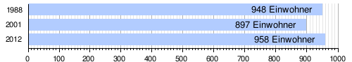
The village had 948 people at the 1988 census, 897 people at the 2001 census, and 958 people at the 2012 census.
During the flood disaster in West and Central Africa in 2010 , 798 residents of Sorbon Haoussa were classified as disaster victims.
Individual evidence
- ↑ Edmond Séré de Rivières: Histoire du Niger . Berger-Levrault, Paris 1965, p. 234-235 .
- ↑ Edmond Séré de Rivières: Histoire du Niger . Berger-Levrault, Paris 1965, p. 239 .
- ↑ Abdourahmane Idrissa, Samuel Decalo: Historical Dictionary of Niger . 4th edition. Scarecrow, Plymouth 2012, ISBN 978-0-8108-6094-0 , pp. xxvii .
- ↑ Recensement Général de la Population 1988: Répertoire National des Villages du Niger . Bureau Central de Recensement, Ministère du Plan, République du Niger, Niamey March 1991, p. 275 ( ceped.org [PDF; accessed January 31, 2018]). www.ceped.org ( Memento of the original dated January 31, 2018 in the Internet Archive ) Info: The archive link was inserted automatically and has not yet been checked. Please check the original and archive link according to the instructions and then remove this notice.
- ^ Répertoire National des Communes (RENACOM). (RAR file) Institut National de la Statistique, accessed November 8, 2010 (French).
- ↑ Répertoire National des localites (ReNaLoc). (RAR) Institut National de la Statistique de la République du Niger, July 2014, p. 521 , accessed on 7 August 2015 (French).
- ↑ Situation des besoins des populations victimes d'inondations (2010) ( Memento of the original from October 16, 2014 in the Internet Archive ) Info: The archive link was inserted automatically and has not yet been checked. Please check the original and archive link according to the instructions and then remove this notice. . Website of the Center d'Information et de Communication, published on September 23, 2010, accessed on March 31, 2012.
Coordinates: 13 ° 47 ' N , 1 ° 40' E