South Eastern Freeway
| South Eastern Freeway | |
|---|---|

|
|
| Basic data | |
| Operator: | DTEI |
| Start of the street: |
Crafers ( SA ) ( 35 ° 0 ′ S , 138 ° 42 ′ E ) |
| End of street: |
Swanport ( SA ) ( 35 ° 9 ′ S , 139 ° 18 ′ E ) |
| Overall length: | 66 km |
|
States : |
|
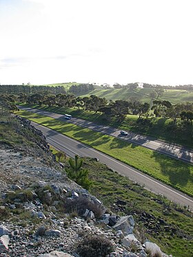
| South Eastern Freeway from the summit of Mount Barker | |
The South Eastern Freeway is a trunk road in the southeast of the Australian state of South Australia . It connects the Adelaide-Crafers Highway in Crafers with the Princes Highway near Swanport on the Murray River . The Adelaide-Crafers Highway merges seamlessly into the South Eastern Freeway without any separate signs. Therefore, they are often viewed as a single motorway by South Australians and mostly just called The Freeway , as this is the first and to this day longest freeway in South Australia. It is part of the national highway network and the Adelaide - Melbourne link and is numbered as the M1 national road.
history
Before the construction of the first freeway in the 1960s, all traffic from Adelaide to the southeastern part of South Australia and the neighboring state of Victoria flowed via a two-lane road that was built in the first half of the 20th century. The population growth in Adelaide resulted in increasing traffic jams on this route and so a new building was necessary, also for safety reasons. Planning began in 1962 and included Crafers as the starting point, due in particular to the high cost of building a new Mount Barker Road (from Adelaide to Crafers).
Construction began in Crafers in 1965. The first construction phase with the carriageway to the east opened in 1967, the second with the carriageway to the west in 1969.
The opening of the new highway caused the load on the longer Bridgewater Railway Line to drop so much that in 1987 passenger traffic on this route had to be abandoned.
The freeway passes many cities that used to be on the two-lane Princes Highway:
- Murray Bridge
- Monarto
- Callington
- Kanmantoo
- Nairne
- Littlehampton
- Mount Barker
- Hahndorf
- Verdun
- Bridgewater
- Aldgate
- Stirling
- Crafers
connections
The northwest end of the road merges seamlessly into the Adelaide-Crafers Highway , which has replaced the narrow, winding Mount Barker Road with the Adelaide Hills since 2000 .
The southeast end of the road at Murray Bridge leads into the Swanport Bridge , a 1 km long, two-lane bridge over the Murray River, to which the Princes Highway - again four lanes - connects towards Tailem Bend . From there, the National Highway 1 continues as a two-lane tourist road through the coastal towns in South Australia and Victoria to Melbourne. The faster way from Tailem Bend to Melbourne is the Dukes Highway (NA8) and its continuation in Victoria, the Western Highway (NA8)
Exits and crossings
|
South Eastern Freeway Princes Highway |
|||
| Exits to the southeast | Removal of Crafers | North-west exits | |
|
Further off the Adelaide-Crafers Highway as the South Eastern Freeway |
0 km |
further than Adelaide-Crafers Highway to , and |
|
| Crafers, Mount Lofty Mount Lofty Tourist Drive Summit Road |
Crafers, Mount Lofty Mount Lofty Tourist Drive Summit Road |
||
|
Stirling , Aldgate Mount Barker Road |
1.2 km |
Stirling , Aldgate Mount Barker Road |
|
|
Bridgewater Bridgewater Road |
5.8 km |
Bridgewater Bridgewater Road |
|
| ADELAIDE-WOLSELEY RAILWAY | 7.0 km | ADELAIDE-WOLSELEY RAILWAY | |
|
Hahndorf , Verdun Mount Barker Road |
8.8 km | 'no exit' | |
|
Mount Barker , Littlehampton, Strathalbyn Adelaide Road |
17.0 km |
Mount Barker , Littlehampton, Strathalbyn North Terrace |
|
| Callington Callington Road |
37.7 km | Callington Callington Road |
|
|
Monarto Zoological Park Ferries McDonald Road |
46.2 km |
Monarto Zoological Park Ferries McDonald Road |
|
|
Murray Bridge , Whites Hill Princes Highway |
55.5 km | 'no exit' | |
|
Murray Bridge , Swanport, Wellington Swanport Road |
66.0 km |
Murray Bridge , Swanport, Wellington Flagstaff Road |
|
|
End of the South Eastern Freeway and continue as Princes Highway to and from |
Start of the South Eastern Freeway further from Princes Highway |
||
Web links
South Eastern Freeway . Ozroads
source
- Steve Parish: Australian Touring Atlas . Steve Parish Publishing. Archerfield QLD 2007, ISBN 978-1-74193-232-4 , pp. 64, 65, 67.
