Springfield (Colorado)
| Springfield | |
|---|---|
|
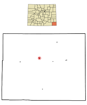
Location in Colorado
|
|
| Basic data | |
| Foundation : | 1889 |
| State : | United States |
| State : | Colorado |
| County : | Baca County |
| Coordinates : | 37 ° 24 ′ N , 102 ° 37 ′ W |
| Time zone : | Central ( UTC − 6 / −5 ) |
| Residents : | 1,451 (as of 2010) |
| Population density : | 630.9 inhabitants per km 2 |
| Area : | 2.3 km 2 (approx. 1 mi 2 ) of which 2.3 km 2 (approx. 1 mi 2 ) is land |
| Height : | 1329 m |
| Postal code : | 81073 |
| Area code : | +1 719 |
| FIPS : | 08-73330 |
| GNIS ID : | 203868 |
| Website : | www.springfieldcolorado.com |
Springfield is the capital of the US administrative division of Baca County in Colorado . According to the 2010 census, it has 1,451 inhabitants.
location
Springfield is north of the Comanche National Grassland at the junction of State Highways 385 and 287. Lamar is 45 miles to the north. Pueblo is 200 km northwest.
education
The town has an elementary school run by Mike Page and a high school with Richard Hargrove as principal. There is also a library there.
economy
There are several restaurants in Springfield, such as a subway . There is also an airport, several banks, leisure facilities such as swimming pools and supermarkets.
Web links
Commons : Springfield (Colorado) - Collection of images, videos, and audio files
Individual evidence
- ↑ http://www.colorado.gov/dpa/doit/archives/muninc.html
- ↑ http://www.naco.org/Counties/Pages/FindACounty.aspx
- ↑ http://www.springfieldcolorado.com/events.html
- ↑ http://www.springfieldcolorado.com/library.html
- ↑ http://www.springfieldcolorado.com/restaurants.html
- ↑ http://www.springfieldcolorado.com/airport.html
- ↑ http://www.springfieldcolorado.com/banks.html
- ↑ http://www.springfieldcolorado.com/recreation.html
