Störtebekerkanal
| Störtebekerkanal | |
|---|---|
| location |
|
| length | 5.5 km |
| Built | 1990s |
| class | 0 |
| Beginning | Leyhorns Sieltief |
| The End | North low |
| Descent structures | Leybuchtsiel |
| Kilometrage | from west to east |
| Top speed. | 8 km / h |
| Competent authority | NLWKN |
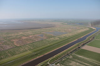
| Aerial view of the Störtebeker Canal | |
The Störtebekerkanal (occasionally also Störtebeker-Graben) is a waterway on the western outskirts of the city in the north in East Frisia . It connects the Leyhörner Sieltief with the Norder Tief .
history
The Norder Tief was initially a direct connection from the Leybucht to the port of the city of Norden. The increasing siltation of the estuary was countered in 1929 with the construction of the Leybuchtsiel . Since the surface water could only flow away when the water was low , an additional pumping station was built in 1962 .
The progressive silting up of the Leybucht made shipping on the Watts fairway more and more difficult. Until 1991, the upstream artificial peninsula Leyhörn with the Leysiel and a storage basin and the Leyhörner Sieltief, which also served as an access to Greetsiel , was built west of the Leybucht . To the east of it, the Störtebeker dike was built as a new flood protection structure, while the Störtebeker Canal was built in the 1990s as a connection between the Leyhörner Sieltief and the old Leybuchtsiel at the mouth of the riverNordertiefs . Since then, the Norder Tief has drained through this canal, the Leyhörner Sieltief and the Leysiel into the North Sea .
function
Through the Störtebekerkanal the waterway to the Norder Hafen is navigable again and it can now be sawn through .
Web links
- Leybuchtsiel and Störtebekerkanal. Retrieved April 10, 2016 .
Coordinates: 53 ° 31 ′ 55 " N , 7 ° 8 ′ 58" E
