
Leysiel
The Leysiel is a combined barrage and Siel with lock northwest of Greetsiel in the municipality Krummhörn ( Ostfriesland ). It was completed in 1991. The coastal protection structure is intended to fulfill three different functions: on the one hand, enable tide-free access to the fishing village of Greetsiel, on the other hand , help secure the drainage of the low-lying, inland dyke areas and, third, also serve to protect nature. The Leysiel is located on a headland called Leyhörn , which has been artificially created since 1985.

Until 1980 there were various plans to dike the entire Leybucht . The last major land reclamation measure before that was the Leybuchtpolder, which was diked from 1947 to 1950 . However, since the Leybucht is a bird resting area of international standing and nature conservation has gained in importance over the decades, the Lower Saxony state government finally decided in 1980 to forego a complete dike in the Leybucht.
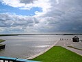
Instead, the aim was now to secure the access to the Greetsieler Hafen , which was previously threatened by silting , by means of a paved, northwest-facing driveway. This was done by creating the headland, which is protected on both sides by dikes and in its interior is largely a body of water. The headland contains a storage basin that serves as a reservoir for the inland water in the event of storm surges (if the water cannot be sown or scooped to the outside dike).
The Leysiel includes a lock to secure the currently 27 Greetsiel shrimp cutters from entering and leaving the port. The sea lock is a total of 120 meters long and has a clear passage width of 14 meters. This allows up to eight cutters to be locked in at the same time. In addition to the fishermen, the Greetsieler Hafen is also approached by boat trips.
With the construction of the Leyhörn, a new dike was built on the south-eastern edge of the Leybucht. This is only marginally in front of the former main dike, the salt marshes in front of it were only touched minimally. This measure made it possible to dig a connecting canal, the Störtebekerkanal from Greetsiel to the 1929 Leybuchtsiel in the northern part of the city. Since then, the Leybuchtsiel no longer drains the Norder Tief directly into the North Sea, but via the canal and reservoir over the Leysiel. It was also rebuilt and provided with an open passage. There is now a canal connection between the north and Greetsiel. For the first time since the construction of the Leybuchtsiel in 1929, the small northern port has access to the open sea again, even if only for boats.
Part of the Leyhörn headland is designated as the “Leyhörn” nature reserve. In addition, compensation areas were provided.
The building cost around 330 million DM .

Overall view of the sewer system

Machine house
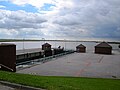
Lock and storage basin
Storage basin
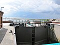
floodgate

Dike and sluice


Ecological consequences
A lot of salt water enters the harbor water through the lock. In combination with the drought and heat in Europe in 2018 , this led to massive fish deaths in the port basin at the end of July 2018 .
Web links
Individual evidence
- ↑ a b c Website of the Nds. State Agency for Water Management, Coastal Protection and Nature Conservation
- ↑ a b c Ufke Cremer / Johann Haddinga : North. The city chronicle. Verlag SKN, Norden 2001, ISBN 3-928327-46-1 , p. 88.
- ↑ Heat: Fish die in Greetsiel and on the Vechte In: ndr.de , August 1, 2018, accessed on August 2, 2018.
Coordinates: 53 ° 32 '8.5 " N , 7 ° 2' 22.8" E