Stackenberger Bach
| Stackenberger Bach | ||
|
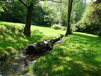
Stackenberger Bach before entering the pond |
||
| Data | ||
| Water code | DE : 273651582 | |
| location | Wuppertal , North Rhine-Westphalia , Germany | |
| River system | Rhine | |
| Drain over | Rottscheidter Bach → Wupper → Rhine → North Sea | |
| source | in the south of the Wuppertal district of Vohwinkel 51 ° 13 ′ 24 ″ N , 7 ° 4 ′ 40 ″ E |
|
| Source height | 237 m above sea level NN | |
| muzzle | on Buchenhofener Strasse in the Rottscheidter Bach Coordinates: 51 ° 14 ′ 9 ″ N , 7 ° 5 ′ 20 ″ E 51 ° 14 ′ 9 ″ N , 7 ° 5 ′ 20 ″ E |
|
| Mouth height | 137 m above sea level NN | |
| Height difference | 100 m | |
| Bottom slope | 49 ‰ | |
| length | 2 km | |
| Catchment area | 97 ha | |
|
The pond of the Stackenberger Bach |
||
|
The transition from the stream to the pond |
||
|
Tributaries and hydraulic structures
|
|||||||||||||||||||||||||||||||||||||||||||||||||||||||||
The Stackenberger Bach is a 2.025 kilometer long brook in the Wuppertal district and district of Vohwinkel . The brook, a tributary of the Wupper , is also the namesake for the streets called Stackenbergstraße and Alt Stackenberg .
etymology
Stackenberg is an old place name, mentioned around 1100 as " Stakelenberg " and around 1250 as " de Stakelberg ". In 1409 it was mentioned as a noble residence and in 1453 in a feudal letter as an estate . The name is interpreted as a reference to a stick = tree stump, according to another interpretation to stakes (= poles). The reference to a personal name "Stakilo" is more likely.
topography
The brook has its source at around 252 meters above sea level in a loosely built area, near Ehrenhainstraße , in the south of the Wuppertal district of Vohwinkel. It flows cased initially in a north-westerly direction and about 180 meters after its source it crosses under the federal motorway 46 (A 46). After crossing under it, it continues to flow in a northerly direction west of the Protestant cemetery Ehrenhainstraße.
After about 530 meters it comes to light in a small, tree-lined stream valley between the cemetery and a field. After another 330 meters, it forms a small pond in a green area near a daycare center . Then it continues piped and follows the course of Ehrenhainstraße , later Stackenbergstraße .
Under Stackenbergstraße , at the confluence with Blücherstraße , 1200 meters after the source, the pipeline turns the direction of flow and the stream is directed to the east below Blücherstraße until Haeselerstraße is reached, and then turned in a northeastern direction. On Buchenhofener Strasse , near the Hammerstein suspension railway station, the Stackenberger Bach joins the Rottscheidter Bach at a height of around 149 meters above zero, and as the Rottscheidter Bach it flows into the Wupper around 100 meters further .
history
The street Stackenberg (meaning here Alt Stackenberg ) was first noted in the address book 1928/29, the street Alt Stackenberg was given its name on November 11, 1987. Stackenbergstrasse was given its name on March 8, 1900 and was called Jägerstrasse between June 18, 1919 and 1935 .
Gut Stackenberg was awarded to Hermann von Hammerstein, a member of the Hammerstein manor , in an inheritance division in 1598 .
The manor was demolished in the second half of 1973, contrary to the original plan, the pond with its old trees was retained.
Web links
Individual evidence
- ↑ a b German basic map 1: 5000
- ↑ a b c flow Geographic Information System of the Wupperverbandes
- ↑ a b Wolfgang Stock: Wuppertal street names . Thales Verlag, Essen-Werden 2002, ISBN 3-88908-481-8
- ↑ Signature: 2258 - AA 002; File number: H 256/933 , accessed February 2010
- ↑ Michael Metschies: Wuppertal rediscovered . Wuppertal 1975, ISBN 3-88094-286-2
- ^ A photo of the Stackenberg estate, accessed April 2008


