
Stahnsdorfer See
| Stahnsdorfer See | ||
|---|---|---|

|
||
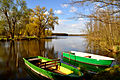
| Stahnsdorfer See in Alt Stahnsdorf | ||
| Geographical location | Central Europe , Germany , Brandenburg , Oder-Spree district | |
| Tributaries | a) from the east: Rieploser Fließ , coming from the Lebbiner See ; b) from the north: Koblenzgraben (from Dolenzgraben / Markgrafpiesker Hauptgraben). | |
| Drain | Stahnsdorfer Fließ to the Storkower Canal ( Storkower waters to the Dahme ) | |
| Places on the shore | Alt Stahnsdorf | |
| Data | ||
| Coordinates | 52 ° 17 '24 " N , 13 ° 53' 15" E | |
|
||
| Altitude above sea level | 34.6 m | |
| surface | 53 ha | |
| scope | 4 km | |
| Maximum depth | 6 m | |
| Middle deep | 2 m | |
|
particularities |
Island with a colony of gray herons |
|

The Stahnsdorfer See is a natural lake in the Oder-Spree district in the Storkow municipality . It is located in the Alt Stahnsdorf district and is part of the Dahme-Heideseen nature park .
geography
The approximately 50-hectare lake is located near the Storkow exit on federal motorway 12 .
ecology
The Stahnsdorfer See has various tributaries in the form of small ditches that originate from the surrounding meadows and wetlands . The outflow of the lake, the Stahnsdorfer Fließ, is located at the entrance to Alt Stahnsdorf and provides a connection to the Storkower Canal . A water mill has been in operation here since 1537 . The mill located there today is one of the architectural monuments of the Storkow region . The flow is almost in its entire course as part of the protected area Storkower channel under conservation .
The western shore of the lake is largely bordered by private property, another part can be reached by taking the riverside path to Neu Stahnsdorf. The eastern bank is predominantly dominated by a wetland. In the middle of the lake there is an island that is now a nature reserve. There is a colony of gray herons on it .
Leisure, tourism, sport
Access to the Stahnsdorfer See is prohibited for motor boats . The Fishing is permitted with a corresponding permission.
See also
Picture gallery
View of the western bank

Stahnsdorfer Fließ and Mühle

