Stanford (California)
| Stanford | |
|---|---|
|
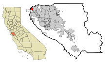
Location in Santa Clara County
|
|
| Basic data | |
| State : | United States |
| State : | California |
| County : | Santa Clara County |
| Coordinates : | 37 ° 25 ′ N , 122 ° 10 ′ W |
| Time zone : | Pacific ( UTC − 8 / −7 ) |
| Residents : | 13,315 (as of: 2000) |
| Population density : | 1,875.4 inhabitants per km 2 |
| Area : | 7.2 km 2 (about 3 mi 2 ) of which 7.1 km 2 (about 3 mi 2 ) is land |
| Height : | 23 m |
| Postcodes : | 94305, 94309 |
| Area code : | +1 650 |
| FIPS : | 06-73906 |
| GNIS ID : | 1867061 |
Stanford is a census-designated place with 13,900 inhabitants (as of 2004) in Santa Clara County in the US state of California near Palo Alto . Stanford is an unincorporated area with a size of 7.2 km². Stanford University is located on a large part of the area .
Sons and daughters of the church
- Reid Hoffman (* 1967), entrepreneur and author
- Andrew WK (* 1979), rock musician
- Adrien Costa (* 1997), racing cyclist
