
Starzlachklamm


The Starzlachklamm is a gorge at the foot of the Grünten between Sonthofen- Winkel and Topfenalpe in Bavaria ( Germany ).
It was washed out by the Starzlach , which rises at an altitude of 1070 m between the Grünten and the Wertacher Hörnle . The name Starzlach means "Ach jumping over the rocks", also "torrent". In the Starzlachklamm one encounters “foaming whirlpools, huge water mills, the high, wildly romantic side gorges, a gate-like rock roof and a dry ridge”. In the gorge, the water tumbles down, among other things, a more than twelve meter high waterfall .
The upper part of the Starzlachklamm lies in the 1972 designated landscape protection area Protection of the Grünten Area , the Great Forest, the German Alpine Road and the Wertachtel . The gorge is protected as a natural monument and has been classified as a valuable geotope by the Bavarian State Office for the Environment .
Geological conditions and fossils


.jpg)
In the Starzlachklamm, rock sequences from the Upper Cretaceous to the Old Tertiary are exposed, which build up the Alpine structure of the Helvetic . In the area of the gorge, the rock sequences are subjected to intensive fracture tectonic stress, so that some strata are exposed several times in the course of the gorge.
From the exit of Sonthofen-Winkel to the Schleierfall in the Starzlachklamm, Würm-age moraine deposits are exposed on the northern side of the valley , which are covered by recent weathering and debris deposits at the foot of the slope . On the south side of the valley, at the level of the sediment catchment basin, there are dark, marl- like urban slates (globigerine marl ) from the Paleocene - Eocene , into which the rocks of the older three-tang and cheek layers were tectonically inserted . In the area of the waterfall, the Eocene Nummulite limestones , which fall 35 ° to WSW , are characterized by intensive fracture tectonic stress in the further course of the gorge. The Starzlachklamm was created in the core of the tectonically complicated Starzlachmulde , which descends to the SW . The course of the river traces an old tectonic weak zone. In the gorge, the so-called ore limestone , about 50 m thick, is exposed , which was the subject of ore mining at various points on the Grünten. In the upper gorge there are marls, limestone and sandstones from the Upper Cretaceous to Old Tertiary three-tang layers , which are locally overlaid on the northern side of the gorge by the debris from a Holocene rock fall . The oldest rocks form the eastern part of the gorge with the marl and limestone of the Wang strata ( Maastrichtian ).
The Starzlach cut deeply into the rock, especially in the narrow gorge sections. The erosive power of the sediment-laden water resulted in numerous vortex pools .
Lenticular nummulites can be found in the fossil-bearing rocks of the steep cliffs . The Latin word nummus means coin. Are meant the coin-shaped animal remains, called Wurzelfüßler (Rhizopods) with calcareous shells, which in Mitteloligozän disappeared in the Alps forming about 30 million years ago in the sea mud. The vernacular also occasionally speaks of penny stones . Geologists and petrographers will find around 15 different types of nummulites in addition to urban slate and ore limestone. These include fossils of the rare crab Xanthopsis sonthofenensis .
Tourist importance
Development

The Starzlachklamm is of considerable tourist importance for the Sonthofen region. The gorge is designated as “Sonthofen’s most important natural monument”. In 1932 the Starzlachklamm was made accessible to tourists for the first time. At that time, the Sonthof builder FX Ammann was active as a developer. The Breitachklamm , a little further south, had been made accessible in this way since 1905.
“Splintered tree trunks, vortex pots and sometimes slippery narrow spaces” characterize the picture on the thundering white water. The “steep path with iron bridges that is sometimes blasted into vertical rock faces” has opened up the Starzlachklamm ever since.
After the damage in World War II , the Starzlachklamm was officially reopened to the public in 1949. On May 12, 1951, the gorge was placed under protection as a natural monument . In 2005 it had to be closed after the fall of a mudflat . It has been accessible again since 2007. Mudslides continue to threaten the gorge and in 2012 and 2015 part of the path had to be closed again. The city of Sonthofen charges an entrance fee for maintaining the paths through the gorge.
Sporting development and use
In addition to the numerous hikers, the Starzlachklamm gains further tourist importance through its use for canyoning . The gorge also plays a role as a climbing area in the Allgäu . In some steep, partly overhanging gorge walls, climbing routes have been created. From 1990, modern sport climbing began here in the Oberallgäu district . "This was the first time that extremely difficult routes were climbed in the Oberallgäu ... that are comparable to international standards". The experience-based educational use is also increasingly playing a role. Due to the designation as a geotope, the Starzlachklamm is also a geotouristically much-visited destination in the Allgäu Geopark .
accessibility
The starting point for the gorge is the hamlet of Winkel north of Sonthofen at an altitude of 760 m . Weiler lies below the point where the Starzlach flows out of the gorge. The Starzlachklamm can also be visited from the upper end of the gorge, which is open to tourists. The upper access to the gorge is orographically to the right of the meadows "Auf dem Ried" at an altitude of 985 m . Touristic circular routes are also laid out and described.
Picture gallery

Sediment trap
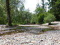
Stream bed gravel in the sediment catch basin
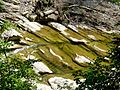
Nummulite limestone cribs in the stream bed
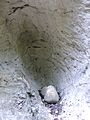
Strudel pot
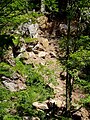
Rock fall in the area of the Berghofer Waldalpe-Weg (2015)
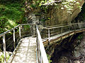
Hiking trail in the gorge


.jpg)
See also
Web links
- Starzlachklamm
- Hike over the Starzlachklamm to the museum village
- Geotope data sheet of the LFU Bavaria: Starzlachklamm NE von Sonthofen
literature
- Klaus Schwerd: Helvetikum, Ultrahelvetikum, Feuerstätter blanket, Rhenodanubian flysch and Arosa zone between Burgberg and Hindelang, excursion guide, excursion G on April 8, 1983 , annual reports and communications from the Upper Rhine Geological Association, Volume 65, Stuttgart 1983, pp. 99–112
- Klaus Schwerd, Rudolf Ebel, Hermann Jerz : Geological map of Bavaria 1:25 000, explanations for sheet no. 8427 Immenstadt i. Allgäu . Munich 1983, 258 pp.
- OM Reis: Die Nummulitenschichten in the Grüntener Bogen , Geognostisches Jahrbuch, volume 39, Munich 1926, p. 22ff.
- B. Höpfner: Stratigraphy and facies distribution in the southern Helvetian Cretaceous-Tertiary boundary layers of the central Allgäu as well as comparisons to the east and west. Doctorate University of Munich, Munich, 1970, 128 pp.
Individual evidence
- ↑ The torrent that jumps over rocks: The Starzlachklamm , in: Dieter Buck, Fundort Natur Allgäu. Excursions to natural sights, Verlag ars vivendi , Cadolzburg 2006, 2nd edition, pp. 81–83, ISBN 3-89716-205-9
- ↑ Dieter Buck, p. 81
- ↑ Protected areas in Germany. Federal Agency for Nature Conservation, accessed on February 12, 2016 .
- ^ Starzlach gorge NE from Sonthofen (780R005). (PDF) In: Bavarian Geotope Register. Retrieved February 12, 2016 .
- ^ Ulrich Lagally, Stefan Glaser, Elisabeth Jobe, Georg Loth, Andreas Murr, Hubert Schmid, Wolfgang Schmid, Klaus Schwerd, Stephan Sieblitz and Ulrich Teipel: Geotope in Schwaben . In: Bavarian State Office for the Environment (Ed.): Earth science contributions to nature conservation . tape 7 . Augsburg 2009, ISBN 978-3-936385-34-2 , pp. 142 .
- ^ Dieter Richter: Allgäu Alps . In: Manfred P. Gwinner (ed.): Collection of geological guides . 3. Edition. tape 77 . Gebr. Borntraeger, Berlin and Stuttgart 1984, ISBN 3-443-15038-1 , p. 164 f .
- ^ Günter Möbus: Geology of the Alps: An introduction to the regional-geological units between Geneva and Vienna . Sven von Loga, Cologne 1997, ISBN 3-87361-249-6 , p. 23 f .
- ↑ Herbert Mayr, hiking alpine upland, compass hiking Vol. 5423, Rum / Innsbruck 2011 1st edition, p 11 ISBN 978-3-85026-374-0
- ↑ starzlachklamm.de
- ↑ sp http://www.sonthofen.de/Stadtinfos/DatenundFakten.aspx accessed on August 30, 2014
- ↑ so http://www.starzlachklamm.de/beschreibung-starzlachklamm.html accessed on August 30, 2014
- ↑ Dieter Buck, p. 82
- ↑ Herbert Mayr, hiking guide Allgäuer Voralpen, p. 11
- ↑ Dieter Buck, p. 82
- ↑ Walter Hölzer, on the page http://www.starzlachklamm.de/klettern.html accessed on September 2, 2014
- ↑ Starzlach Gorge. Geopark Allgäu, accessed on February 12, 2016 .
- ↑ Description and a. from Dieter Seibert, in: Allgäu Alps and Ammergau Alps. Alpine Club Guide, ed. by the German and Austrian Alpine Club, Bergverlag Rother, Munich 2004, 16th edition, ISBN 3-7633-1126-2 , p. 39
Coordinates: 47 ° 31 ′ 52 " N , 10 ° 18 ′ 39" E