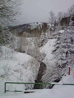
Steindöbra (river)
| Stone Dobra | ||
|
Winter view of the Steindöbra looking towards Aschberg at the level of Bärenloch, halfway between the confluence with the Mühlbach and the confluence with the Brunndöbra. |
||
| Data | ||
| Water code | DE : 5323428 | |
| location | Klingenthal , Vogtland , Saxony | |
| River system | Elbe | |
| Drain over | Brunndöbra → Zwota → Eger → Elbe → North Sea | |
| source | near the Mühlleithen pass, 50 ° 24 ′ 20 ″ N , 12 ° 29 ′ 28 ″ E |
|
| Source height | approx. 854 m | |
| muzzle | in the Brunndöbra coordinates: 50 ° 22 ′ 18 ″ N , 12 ° 28 ′ 10 ″ E 50 ° 22 ′ 18 ″ N , 12 ° 28 ′ 10 ″ E |
|
| Mouth height | approx. 564 m | |
| Height difference | approx. 290 m | |
| Bottom slope | approx. 63 ‰ | |
| length | 4.6 km | |
The Steindöbra is a brook in the Saxon Vogtland . Above the confluence of the Steinbach it also bears the name Mühlbach.
geography
The source is located at an altitude of about 854 meters near the summit Mühlleithen in Westerzgebirge . Then it flows southwards through the Steindöbra district of Klingenthal , to flow into the Brunndöbra after about 4.6 kilometers of running . Its water reaches the North Sea via the rivers Zwota , Eger and Elbe .
Others
A large part of its course, after the confluence with the Steinbach and up to the confluence with the Brunndöbra, runs parallel to the route of the former Klingenthal – Sachsenberg-Georgenthal narrow-gauge railway .
Tributaries
The Steinbach (r) is a tributary of the Steindöbra.
Web links
literature
- The Upper Vogtland (= values of our homeland . Volume 26). 1st edition. Akademie Verlag, Berlin 1976.

