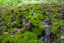
Stone Gully (Happurg)
Coordinates: 49 ° 28 ′ 18 ″ N , 11 ° 31 ′ 31 ″ E
The Steinerne Gully near Thalheim is a limestone turf channel in the Förrenbach district of the municipality of Happurg in the Middle Franconian district of Nürnberger Land in Bavaria . The tufa-lime spring with the stone channel is under nature protection as a tufa-lime spring due to the Federal Nature Conservation Act § 30 Para. 2 No. 1 + 2 in connection with Article 23 of the Bavarian Nature Conservation Act and Directive 92/43 / EEC according to habitat type 7220.
location
The Steinerne Rinne is located about 1.8 kilometers northwest of the Happurg district of Thalheim in the Southern Jura landscape protection area with Moritzberg and the surrounding area on the right lower valley slope of the Rohrbach immediately to the right of the state road St 2236 in the direction of Happurg. It is also part of the Fauna-Flora-Habitat- Area eaves of the Hersbrucker Alb (FFH-Nr. 6434-301; WDPA-Nr. 555521544)
Description and history of origin
The gutter is a section of the bed of a rivulet only 230 meters long and running westwards on the right lower slope of the valley. Here pours at about 420 m above sea level. NHN the so-called Hochholz-Quelle, in nature there are two smaller springs close together. The draining water was dammed in the upper course at the level of a hut, then it changes direction and flows flat down the slope; here it has created numerous smaller sintered terraces over a length of around 50 meters . About 120 meters below the springs, just before the road, the 15-meter-long, up to 60-centimeter-high, moss-covered calcareous trough begins on a steep, 3-meter-high step. The water then crosses under the state road in a pipe and finally empties after less than 100 meters at over 380 m above sea level. NHN in the Rohrbach, a source river of the Happurger Bach .
The channel is relatively young and until a few years ago looked more like a sinter terrace . It is almost natural.
Geological situation
The source horizon is designed as a reservoir source at the geological boundary between the iron sandstone ( Dogger Beta ) and the underlying Opalinus Clay (Dogger Alpha). Due to its lower permeability , the Opalinus Clay forms a lower aquifer , at the top of which the groundwater accumulates and emerges as a low-pouring spring . In the entire valley, this layer boundary forms the so-called Dogger spring horizon. The high wood source, which is responsible for the formation of the Steinerne Rinne near Happach, has an average flow rate of 10–12 l / s and, from a hydrochemical point of view, is a calcium - magnesium - hydrogen carbonate source.
Various morphological forms of tufa formations occur in the vicinity of the tufa limestone source on Hochholz: In the immediate area of the source there is still no significant lime precipitation, in the upper slope there is an accumulation of porous limestone tuffs in the form of sintered terraces and tuff cascades, while a tufa gully forms in the lower slope. Such limestone deposits arise mainly with the involvement of strong nerve mosses ( Cratoneuron commutatum ), which live in the spring and brook bank area and remove carbon dioxide from the spring water through photosynthesis and are petrified in the process.
The loose, porous, slightly solidified tufa formations with the involvement of strong-nerved mosses are sensitive to footsteps and, due to their rare occurrence, are classified as priority habitats according to the Habitats Directive .
Web links
- Hochholzquelle and western stream on the BayernViewer
- Signs of the geological-geomorphological nature trail in Happurg (here Fig. 3: Stone channel on the road between Förrenbach and Thalheim )
Individual evidence
- ^ Tufa springs (cratoneurion). Habitat types of the European Natura 2000 system of protected areas . Retrieved March 14, 2017.
- ↑ List of the species occurring in Germany in Appendix II of the Fauna Flora Habitat Directive. In: Germany's nature. Retrieved March 14, 2017 (private website).
- ↑ Section 30, Paragraph 2, No. 1 + 2 of the Federal Nature Conservation Act
- ↑ World Database on Protected Areas - eaves slopes of the Hersbrucker Alb (English)
- ^ Fritz Goetze, Helmut Gudden, Rolf Meyer, Bernd: Geological Map of Bavaria, 1: 25,000, sheet 6535 Alfeld , Munich 1983.
- ^ Rolf Apel: Hydrogeological conditions . In: Rolf KF Meyer: Geological Map of Bavaria 1: 25,000, sheet 6535 Alfeld, explanations , Munich 1983, 127 pp.
- ↑ Kalktuffquellen: Distribution , accessed on July 30, 2014.
- ^ Rolf KF Meyer: Geological map of Bavaria 1: 25,000, sheet 6535 Alfeld, explanations , Munich 1983, p. 126.
- ↑ Kalktuffquellen: Flora , accessed on July 30, 2014.
- ^ Project group action program sources: Bavarian source type catalog . Bavarian State Office for Water Management (Ed.), Munich 2004, p. 75ff .; Bavarian source type catalog, online , accessed on July 30, 2014.


