Förrenbach
|
Förrenbach
community Happurg
Coordinates: 49 ° 28 ′ 33 ″ N , 11 ° 30 ′ 10 ″ E
|
|
|---|---|
| Height : | 373 m |
| Postal code : | 91230 |
| Area code : | 09151 |
|
Förrenbach, typical street view
|
|
The parish village of Förrenbach (Franconian: Fīrabo ) is part of the municipality of Happurg in the central Franconian district of Nürnberger Land . The parish village has about 800 inhabitants and was first mentioned in a document in 1011. About a kilometer away is Lake Happurg with the Happurg pumped storage plant .
history
The place name "Furihinebach", first mentioned in 1011, can be traced back to pine or trout . In that year, the later Emperor Heinrich II gave the place to the diocese of Bamberg . Later the Lords of Reicheneck also had some property in Förrenbach. Their ancestral seat, Reicheneck Castle , lay west of the village. Today it is a ruin with little preserved building fabric. From 1504 the place came to the imperial city of Nuremberg , which owned it until 1806.
The Protestant parish church of St. Johannes was built in 1839 on the site of a demolished Gothic church building. It was planned in the late classical style by the architect Schulz, a student of Leo von Klenze .
Concentration camp memorial
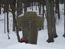
About one kilometer west of Förrenbach is the concentration camp memorial , with which the memory of the crematorium of the Hersbruck satellite camp is kept alive. In the last months of the Second World War, numerous victims of the subcamp were cremated there who had succumbed to the harsh conditions of camp life and labor.
The memorial is about 150 meters south of the shoreline of Lake Happurger See on the edge of a forest area. It consists of a massive stone cross about two meters high with only a short inscription. Just like the two concentration camp memorials at Schupf and Hubmersberg , this memorial was also erected by the Hersbruck district at the beginning of the 1950s . The original installation site was initially at the same location as the crematorium. Before this place was flooded with the damming of Lake Happurger See in 1955, the memorial was moved so that it is now about 30 meters above the level of the reservoir. A granite signpost on the edge of State Road 2236 points to the remote and hidden memorial.
Worth seeing
- In addition to some listed houses , the Evangelical Lutheran Church of St. John is located in the center of the village. See also: Monuments in Förrenbach
- The nature reserve Upper Molsberger Tal is located south of the village .
- To the west of the village are the ruins of Reicheneck Castle on the Schlossbühl, and there was also a castle on the Vogelfels to the south-east during the Middle Ages , but no historical information is known about it, and it has only been preserved as a castle stables , i.e. as an abandoned castle.
- From the Wachfelsen to the north there is an impressive view of Förrenbach and the valley of the Happurger Bach.
- The Felsburg Teufelskanzel is located between Thalheim and Förrenbach .
literature
- Nuremberg country . Karl Pfeiffer's Buchdruckerei und Verlag, Hersbruck 1993, ISBN 3-9800386-5-3 .
Web links
- Memorials (Retrieved August 9, 2012)
Individual evidence
- ^ Location of Förrenbach in the Bavaria Atlas
- ↑ Fränkischer Albverein (Ed.): Driving and hiking, Volume 3 . Verlag Neue Presse, Nuremberg 1992, ISBN 3-920701-90-9 , p. 252.


