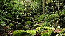
Stillenstein Gorge
The Stillensteinklamm is a gorge of the Gießenbach in the eastern part of Grein or in the western part of St. Nikola im Strudengau in the Perg district in Upper Austria , which can be accessed via a hiking trail .
geography
The Stillenstein Gorge lies at an altitude of between 230 m above sea level. A. (Gießenbachmühle) and 405 m above sea level. A. (Aumühle) and has a length of about five kilometers. Due to its course through the Stillenstein Gorge, the Gießenbach is one of the most interesting bodies of water in the Upper Austrian spatial unit of the Danube Gorge and side valleys . The naturalness of its water regime is impaired by a diversion section for a small power plant just before it flows into the Danube.
In some places the Gießenbach flows through an underground cave system. One of the caves is up to eight meters high, more than a hundred meters accessible and has two entrances. The Stillenstein Gorge owes its name to it because the Gießenbach disappears underground and is therefore quiet. The cave may not be entered when thunderstorms and rain are imminent, as well as during the regulatory measures of the power plant located above the cave.
history
In the first half of the 19th century, the Gießenbach was made usable for the failure flood by blasting boulders (1834 to 1836) . Around 12,000 fathoms of wood were transported in the following ten years . In the second half of the 19th century (around 1880) the gorge was made accessible to hikers through the construction of paths, bridges, stairs and climbing systems, which, however, were destroyed several times by flood disasters (1915, 2002, 2005). The Donauuferbahn has been crossing the Gießenbach Valley near the Gießenbachmühle via a viaduct with seven arches since 1909. It is the highest railway viaduct between Sankt Valentin and Vienna .
tourism
The number of hikers in the gorge, which has been hiked with interruptions since 1880, can only be estimated. When it reopened in 2006, there was talk of 20,000 hikers a year. Since 2010, the Stillenstein Gorge has been part of the Donausteig stage from Grein to Sarmingstein and part of the Donaurunde Burg Werfenstein after extensive renovation of the hiking trail . The entrance to the Stillenstein Gorge at the Gießenbachmühle at the confluence of the Gießenbach and the Danube is on the Danube Cycle Path .
literature
- Franz and Rudolf Hauleitner: Wachau with Waldviertel, 50 tours , Rother hiking guide, Bergverlag Rother , Munich, 4th edition 2008, ISBN 9783763340255 , section 31 Stillensteinklamm, cool tip for hot days, S 98ff, Stillensteinklamm
Web links
Individual evidence
- ↑ Room unit Danube Gorge and side valleys (PDF; 1.9 MB)
- ↑ A legendary cave found in Stillensteinklamm - Christine and Reinhard Koch from Grein have now revealed their secret, in: Mein Bezirk Perg, Bezirksrundschau No. 45, November 10th 2011 p 6
Coordinates: 48 ° 14 ′ 27 ″ N , 14 ° 52 ′ 50 ″ E


