Stolzemburg
|
Stolzemburg ( dt. ) Stolzebuerg ( lux. ) Stolzembourg ( fr. ) community Puetscheid
|
||
|---|---|---|
| Coordinates : | 49 ° 58 ' N , 6 ° 10' E | |
| Residents : | 170 (2005) | |
| Postcodes : | 9463, 9464 | |
|
Location of Stolzemburg in Luxembourg
|
||
|
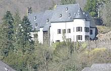
Stolzemburg seen from the border
|
||
Stolzembourg ( lux .: Stolzebuerg , French: Stolzembourg ) is a small village, part of the municipality of Pütscheid , in northeastern Luxembourg . In 2005 the village had about 170 inhabitants . Stolzebuerg is located in the Ourtal and on the River Our , 6 km north (upstream) of Vianden and on the Our Nature Park .
history
The village image of Stolzemburg is characterized by the modern castle built on a hill with the church building at the foot of the castle hill . The massive tower preserved from the old church in 1761 points to the church built in 1885. The first church in Stolzemburg was probably the castle chapel . In the village, the bell tower, built before 1585, and the church bear witness to the history of the village and its parish.
Copper mining in Stolzemburg
1.5 km from Stolzemburg are the remains of the former copper mine , where copper ore was mined for several centuries .
For more than 500 years, the copper-bearing ore veins of the "Klangbach" have drawn several investors to Stolzemburg, even though it is a bit remote from the industrial areas. By 1856–1938, the mining had reached considerable proportions. Up to 5000 tons of copper ore were mined here in the past . Despite frequent problems from water ingress, the mine worked profitably.
During the German occupation in World War II , copper was mined here for the armaments industry .
Since the pumps necessary for dewatering have been switched off in the tunnels that have not been used for over 50 years, the majority of the tunnels are flooded.
The Kupfergrube Museum ( Musée Koffergrouf ) provides information about copper mining in the village . In recent years, part of the underground tunnels has been made accessible to the public.
Stolzemburg Castle
The castle of Stolzemburg is located on a hill near the center of the village, it was destroyed in 1454 by the governor Antoine I. de Croÿ . Later rebuilt, in 1679 it fell victim to the siege troops Louis XIV of France. It was converted into a country house in the Scottish style around 1898 and is now privately owned.
Personalities
- Jacques Mangers , former Bishop of Oslo


