
Strážovské vrchy
Coordinates: 48 ° 55 ' N , 18 ° 30' E

The Strážovské vrchy ( German Rajetz Mountains ) are a core mountain range in western Slovakia .
The highest mountain is the Strážov with 1213 m nm , the most visited by tourists, however, the Vápeč with 956 m nm , which offers visitors interesting photo motifs of the limestone and dolomite rock landscapes .
Part of the mountain has been part of the almost 31,000 hectare Strážovské vrchy protected landscape area since 1989 . Most of the area is covered by mixed forests.
The largest settlements in the area are Trenčianske Teplice , the Bojnice thermal springs , Dubnica nad Váhom , Rajecké Teplice , Ilava and the town of Čičmany, which is known for its historical and folk architecture .
gallery

Vápeč (955 m)

Holazne (901 m)
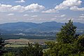
View of the Vtáčnik Mountains
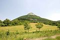
Vápeč from Horná Poruba


Individual evidence
- ^ Frieder Monzer: "Strážovské + vrchy" + "Rajetzer + Berge Slovakia: On the way between the Danube, Tatras and Beskydy , Google Books, page 31