Stralauer Tor
The Stralauer Tor was part of the Berlin fortifications .
Medieval city wall
The Stralauer Tor of the first Berlin city wall was located in the southeast of the medieval twin cities of Berlin-Cölln . It was located at the current intersection of Stralauer Strasse and Littenstrasse . Today there are no more traces of this gate.
Excise wall
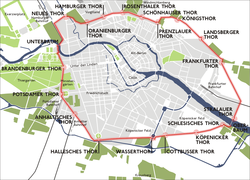
The Stralauer Tor was moved further to the east with the Berlin customs wall built under Friedrich Wilhelm I from 1732 . The gate was at the end of the bridge on Oberbaum on the Berlin side at today's intersection of Stralauer Allee and Warschauer Straße .
The erection of the excise wall meant the largest urban expansion of old Berlin, whereby the old ramparts were removed in order to create a better connection between the inner city and the new and suburbs. The northern city wall closed at the end of the 17th century before the Berlin fortification wall resulting Stralauer suburban one. From the south-east, directly at the end of the bridge on Oberbaum, Stralauer Tor (also Mühlentor), an avenue laid out on a dam led to the fishing village of Stralau .
For a long time, the rural gate section was certainly one of the quietest in the entire curtain wall. After the railway line to Frankfurt along the Spree went into operation in 1842, however, in connection with the industrialization of Berlin, the dense development of this part of the Stralau suburb began. Characteristic of this development is the first Berlin waterworks, which was built outside the city wall in spring 1856 between the track and Stralauer Allee and operated until 1894.
Nine gates broke through the north arch of the wall. The Stralauer Tor was followed by: Frankfurter Tor , Landsberger Tor , Bernauer Tor (later Königstor ), Prenzlauer Tor , Schönhauser Tor , Rosenthaler Tor , Hamburger Tor , Oranienburger Tor ; a tenth ( new gate ) was added later.
The excise wall, which initially consisted of palisades , was replaced on the Berlin side from 1787 by a massive stone wall that was partially straightened to better round off the area. In the 1860s, the demolition of the city wall began, which continued into the 1880s and did not stop at the gates, which were attractive in terms of urban planning. Of the ten gates in this section, only the New Gate remained.
Subway station
From 1896 an underground station was built at this point, which was called "Stralauer T (h) or" and was inaugurated in 1902. In 1924 it was renamed the Osthafen underground station .
literature
- Friedrich FA Kuntze: The old Berlin . Verlag für Kunstwissenschaft, Berlin and Leipzig 1937, p. 19.
- Karlheinz Gerlach (editor): Description of the royal residence city of Berlin - a selection. The edition is based on Friedrich Nicolai's description of the royal residence cities of Berlin and Potsdam, all the peculiarities located there, and the surrounding area , Berlin 1786. Verlag Philipp Reclam jun., Leipzig, 1987, p. 103.
- Bodo Harenberg (editor): The Chronicle of Berlin . Chronik Verlag, Dortmund 1991, p. 115.
- Herbert Schwenk: Lexicon of Berlin Urban Development ; Haude & Spenersche Verlagbuchhandlung, Berlin 2002, ISBN 3-7759-0472-7 , p. 108.
Coordinates: 52 ° 30 '9.6 " N , 13 ° 26" 49.6 " E


