Littenstrasse
| Littenstrasse | |
|---|---|
| Street in Berlin | |
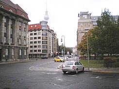
| View of the road from south to north. | |
| Basic data | |
| place | Berlin |
| District | Berlin center |
| Created | before the 19th century |
| Newly designed | 1965 (shortened) |
| Hist. Names | New Friedrichstrasse (18th century) |
| Cross streets | Rolandufer (south), Stralauer Straße, Voltairestraße, Parochialstraße, Grunerstraße (north) |
| Places | no |
| Buildings | Buildings and open spaces |
| use | |
| User groups | Road traffic |
| Technical specifications | |
| Street length | 460 meters |
The Littenstraße is a street in Berlin's district of Mitte in the same district center and one of the oldest roads of the capital . It bears its name after the lawyer Hans Litten , who died in February 1938 by suicide in the Dachau concentration camp after several years of imprisonment and torture . There are numerous historical cultural monuments along Littenstrasse .
History of the road
Around 1746, when the Berlin fortifications had been removed, the street emerged as Neue Friedrichstrasse from the merging of individual alleys. At that time it led in an arch from the Waisenbrücke to the Pomeranzenbrücke on Museum Island and crossed the districts of Klosterviertel , Marienviertel and Heilig-Geist-Viertel in old Berlin . He followed the development on the medieval city wall and the royal moat in front of it. The first buildings erected along this traffic route were primarily used for military purposes, such as the garrison church (no longer preserved).
On May 10, 1951, Neue Friedrichstrasse was named Littenstrasse. With the new construction of the city center ( East Berlin ) and the Berlin television tower in the years 1965–1969, Littenstrasse between Grunerstrasse and An der Spandauer Brücke was eliminated, so that two separate streets were created. The part between Spandauer Strasse and Friedrichsbrücke was assigned to Burgstrasse in 1978 and renamed Anna-Louisa-Karsch-Strasse in 2001 .
Littenstrasse has existed in its current street length since 1965.
Buildings and open spaces
The following buildings are on the east side of the street:
- The Schicklerhaus built in 1910 at the intersection of Littenstrasse and Stralauer Strasse in neoclassical style .
- The Berlin-Mitte fire station is located at the junction with Voltairestraße 2 .
- The "Hans-Litten-Haus" is located at Littenstrasse 9. There is a memorial plaque for Hans Litten on the facade .
- The main offices of the German Lawyers' Association and the German Association of Tax Advisors are located at Littenstrasse 11 and Littenstrasse 10 in the House of Associations (Littenstrasse 9-11).
- At the current end of Littenstrasse 11-17 on the corner of Grunerstrasse is the building of the then regional and district court (today: regional court Berlin ) , which was built in the years 1896-1905 in a mix of neo-baroque , art nouveau and gothic styles . It was once the second largest building in the city, only surpassed by the castle .
The following buildings and open spaces are located on the western side of the street:
- The former administration building of Berliner Gaswerke AG (GASAG) is located at the beginning of Littenstraße on the corner of Am Rolandufer . The building in neo-renaissance style was built between 1907 and 1909 based on a design by Ludwig Hoffmann . Today it is the seat of the private BEST Sabel University of Applied Sciences in Berlin. The building is a listed building .
- A residential and commercial building is located at the intersection of Littenstrasse and Stralauer Strasse .
- A green area begins after the residential and commercial building. There are still remnants of the old city wall between Littenstrasse and Waisenstrasse . They were saved from grinding because they served as the boundary wall of residential buildings. In 1948 the remains of the wall were secured and listed as a historical monument. This is also where the restaurant at the last instance is located .
- This is followed by the ruins of the monastery church built around 1250 in the early Gothic style for the gray monastery of the Franciscans , which was destroyed in the Second World War.
literature
Institute for Monument Preservation (Ed.): The architectural and art monuments of the GDR. Capital Berlin-I . Henschelverlag, Berlin 1984, p. 72-75 .
Web links
-
Littenstrasse. In: Street name lexicon of the Luisenstädtischer Bildungsverein (near Kaupert )
- New Friedrichstrasse . In: Luise.
- Anna-Louisa-Karsch-Strasse near Luise
Coordinates: 52 ° 30 ′ 55 ″ N , 13 ° 24 ′ 55 ″ E

